Bingara geodata
Bingara (New South Wales) is a populated place; located in Australia in Australia/Sydney (GMT+11) time zone. With population of 1,435 people, there are 3335 cities with bigger population in this country. Compared to other cities in Australia, 72.4% of cities are located further ↓South; 59.2% of cities are located further ←West and 87.5% of cities have lower elevation than Bingara. Note1


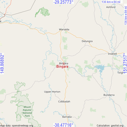
Bingara GPS coordinates[2]
29° 52' 9.516" South, 150° 34' 19.344" East
| Map corner | latitude | longitude |
|---|---|---|
| Upper-left | -29.25773°, | 149.86892° |
| Center: | -29.86931°, | 150.57204° |
| Lower-right: | -30.47716°, | 151.27517° |
| Map W x H: | 135.6×135.6 km | = 84.3×84.3mi |
| max Lat: | -10.58257° ⇑27.6% North |
| Bingara: | -29.86931° |
| min Lat: | ⇓72.4% South -43.31423° |
| min Long | Bingara | max Long |
| 113.53327° | 150.57204° | 153.61246° |
| W 59.2%⇐ | ⇒40.8% E |
Elevation
Elevation of Bingara is 302 m = 991 ft, and this is 180 m = 591 ft above average elevation for this country.
| Max E: |
1715 m = 5627 ft | 12.5% |
| Bingara | 302 m 991 ft | |
| Avg. | 122 m = 400 ft | |
Min E: |
-2 m = -7 ft | 87.5% |
See also: Australia elevation on elevation.city.
Geographical zone
Bingara is located in South temperate zone (between Tropic of Capricorn and the Antarctic Circle). Distance of this Southern Tropic circle is 715.2 km =444.4 mi to North.| Distance of | km | miles | from Bingara |
|---|---|---|---|
| Equator | 3321.2 | 2063.7 | to North |
| Tropic Capricorn | 715.2 | 444.4 | to North |
| Antarctic Circle | 4080 | 2535.2 | to South |
| South Pole | 6685.9 | 4154.4 | to South |


Nearby cities:
15 places around Bingara: (largest is in red/bold)
• Ashford
79 km =49.1 mi,  39°
39°
• Barraba
57.5 km =35.7 mi,  176°
176°
• Blair Athol
93.9 km =58.3 mi,  202°
202°
• Boggabri
106.4 km =66.1 mi,  208°
208°
• Bundarra
59.1 km =36.7 mi,  124°
124°
• Delungra
34.5 km =21.4 mi,  46°
46°
• Emmaville
109.8 km =68.2 mi,  64°
64°
• Gilgai
52.7 km =32.7 mi,  87°
87°
• Guyra
112.3 km =69.8 mi,  110°
110°
• Inverell
53.1 km =33 mi,  78°
78°
• Manilla
98.7 km =61.3 mi,  171°
171°
• Moree
83.8 km =52.1 mi,  302°
302°
• Narrabri
91.3 km =56.7 mi,  236°
236°
• Tingha
62.5 km =38.8 mi,  98°
98°
• Warialda
36.2 km =22.5 mi,  0°
0°
Sources, notices
• [Note1] Compared only with cities in Australia existing in our database
• [Src1] Map data: © OpenStreetMap contributors (CC-BY-SA)
• [Src2] Other city data from geonames.org with taken over terms of usage.
• [Src3] Geographical zone / Annual Mean Temperature by Robert A. Rohde @ Wikipedia
