Mungindi geodata
Mungindi (New South Wales) is a populated place; located in Australia in Australia/Brisbane (GMT+10) time zone. With population of 589 people, there are 4599 cities with bigger population in this country. Compared to other cities in Australia, 73.2% of cities are located further ↓South; 52.6% of cities are located further ←West and 78.5% of cities have lower elevation than Mungindi. Note1


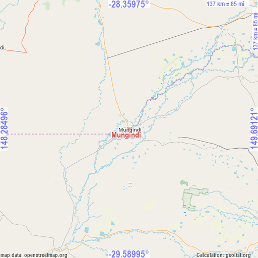
Mungindi GPS coordinates[2]
28° 58' 36.048" South, 148° 59' 17.088" East
| Map corner | latitude | longitude |
|---|---|---|
| Upper-left | -28.35975°, | 148.28496° |
| Center: | -28.97668°, | 148.98808° |
| Lower-right: | -29.58995°, | 149.69121° |
| Map W x H: | 136.8×136.8 km | = 85×85mi |
| max Lat: | -10.58257° ⇑26.8% North |
| Mungindi: | -28.97668° |
| min Lat: | ⇓73.2% South -43.31423° |
| min Long | Mungindi | max Long |
| 113.53327° | 148.98808° | 153.61246° |
| W 52.6%⇐ | ⇒47.4% E |
Elevation
Elevation of Mungindi is 163 m = 535 ft, and this is 41 m = 135 ft above average elevation for this country.
| Max E: |
1715 m = 5627 ft | 21.5% |
| Mungindi | 163 m 535 ft | |
| Avg. | 122 m = 400 ft | |
Min E: |
-2 m = -7 ft | 78.5% |
See also: Australia elevation on elevation.city.
Geographical zone
Mungindi is located in South temperate zone (between Tropic of Capricorn and the Antarctic Circle). Distance of this Southern Tropic circle is 616 km =382.8 mi to North.| Distance of | km | miles | from Mungindi |
|---|---|---|---|
| Equator | 3221.9 | 2002 | to North |
| Tropic Capricorn | 616 | 382.8 | to North |
| Antarctic Circle | 4179.3 | 2596.9 | to South |
| South Pole | 6785.2 | 4216.1 | to South |


Nearby cities:
15 places around Mungindi: (largest is in red/bold)
• Ashford
208 km =129.2 mi,  100°
100°
• Bingara
182.7 km =113.5 mi,  122°
122°
• Boggabilla
139.9 km =86.9 mi,  72°
72°
• Collarenebri
74.7 km =46.4 mi,  212°
212°
• Delungra
193.8 km =120.4 mi,  112°
112°
• Dirranbandi
86.1 km =53.5 mi,  300°
300°
• Goondiwindi
137 km =85.1 mi, 69°
• Inglewood
213.4 km =132.6 mi, 73°
• Lightning Ridge
110 km =68.4 mi,  242°
242°
• Moree
98.9 km =61.5 mi, 123°
• Narrabri
168.4 km =104.6 mi,  152°
152°
• St George
120.2 km =74.7 mi,  342°
342°
• Walgett
143.9 km =89.4 mi,  215°
215°
• Warialda
166.4 km =103.4 mi, 112°
• Wee Waa
145.7 km =90.5 mi,  162°
162°
Sources, notices
• [Note1] Compared only with cities in Australia existing in our database
• [Src1] Map data: © OpenStreetMap contributors (CC-BY-SA)
• [Src2] Other city data from geonames.org with taken over terms of usage.
• [Src3] Geographical zone / Annual Mean Temperature by Robert A. Rohde @ Wikipedia
