Warracknabeal geodata
Warracknabeal (Victoria) is a populated place; located in Australia in Australia/Melbourne (GMT+11) time zone. With population of 2,372 people, there are 2646 cities with bigger population in this country. Compared to other cities in Australia, 79.3% of cities are located further ↑North; 74.4% of cities are located further →East and 71.1% of cities have lower elevation than Warracknabeal. Note1


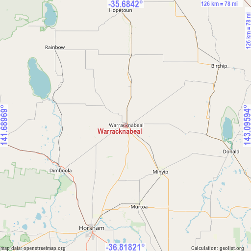
Warracknabeal GPS coordinates[2]
36° 15' 11.736" South, 142° 23' 34.116" East
| Map corner | latitude | longitude |
|---|---|---|
| Upper-left | -35.6842°, | 141.68969° |
| Center: | -36.25326°, | 142.39281° |
| Lower-right: | -36.81821°, | 143.09594° |
| Map W x H: | 126.1×126.1 km | = 78.4×78.4mi |
| max Lat: | -10.58257° ⇑79.3% North |
| Warracknabeal: | -36.25326° |
| min Lat: | ⇓20.7% South -43.31423° |
| min Long | Warracknabeal | max Long |
| 113.53327° | 142.39281° | 153.61246° |
| W 25.6%⇐ | ⇒74.4% E |
Elevation
Elevation of Warracknabeal is 109 m = 358 ft, and this is 13 m = 43 ft below average elevation for this country.
| Max E: |
1715 m = 5627 ft | 28.9% |
| Avg. | 122 m = 400 ft | |
| Warracknabeal | 109 m = 358 ft | |
Min E: |
-2 m = -7 ft | 71.1% |
See also: Australia elevation on elevation.city.
Geographical zone
Warracknabeal is located in South temperate zone (between Tropic of Capricorn and the Antarctic Circle). Distance of this Southern Tropic circle is 1425.1 km =885.5 mi to North.| Distance of | km | miles | from Warracknabeal |
|---|---|---|---|
| Equator | 4031 | 2504.7 | to North |
| Tropic Capricorn | 1425.1 | 885.5 | to North |
| Antarctic Circle | 3370.2 | 2094.1 | to South |
| South Pole | 5976.1 | 3713.4 | to South |


Nearby cities:
15 places around Warracknabeal: (largest is in red/bold)
• Birchip
55.8 km =34.7 mi,  57°
57°
• Charlton
85.7 km =53.3 mi,  90°
90°
• Dimboola
39.3 km =24.4 mi,  235°
235°
• Donald
54.2 km =33.7 mi,  103°
103°
• Halls Gap
100 km =62.1 mi,  173°
173°
• Haven
59.1 km =36.7 mi,  197°
197°
• Hopetoun
58.6 km =36.4 mi,  357°
357°
• Horsham
53.8 km =33.4 mi, 198°
• Murtoa
41.3 km =25.7 mi, 170°
• Nhill
67.2 km =41.8 mi,  262°
262°
• Rainbow
53.3 km =33.1 mi,  318°
318°
• Rupanyup
46.9 km =29.1 mi,  152°
152°
• Sea Lake
92.9 km =57.7 mi,  26°
26°
• Stawell
95.8 km =59.5 mi,  158°
158°
• Wycheproof
77.4 km =48.1 mi,  75°
75°
Sources, notices
• [Note1] Compared only with cities in Australia existing in our database
• [Src1] Map data: © OpenStreetMap contributors (CC-BY-SA)
• [Src2] Other city data from geonames.org with taken over terms of usage.
• [Src3] Geographical zone / Annual Mean Temperature by Robert A. Rohde @ Wikipedia
