Bourke geodata
Bourke (New South Wales) is a populated place; located in Australia in Australia/Sydney (GMT+11) time zone. With population of 2,029 people, there are 2883 cities with bigger population in this country. Compared to other cities in Australia, 72.2% of cities are located further ↓South; 57.3% of cities are located further →East and 71.5% of cities have lower elevation than Bourke. Note1


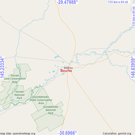
Bourke GPS coordinates[2]
30° 5' 24.396" South, 145° 56' 11.256" East
| Map corner | latitude | longitude |
|---|---|---|
| Upper-left | -29.47988°, | 145.23334° |
| Center: | -30.09011°, | 145.93646° |
| Lower-right: | -30.6966°, | 146.63959° |
| Map W x H: | 135.3×135.3 km | = 84.1×84.1mi |
| max Lat: | -10.58257° ⇑27.8% North |
| Bourke: | -30.09011° |
| min Lat: | ⇓72.2% South -43.31423° |
| min Long | Bourke | max Long |
| 113.53327° | 145.93646° | 153.61246° |
| W 42.7%⇐ | ⇒57.3% E |
Elevation
Elevation of Bourke is 110 m = 361 ft, and this is 12 m = 39 ft below average elevation for this country.
| Max E: |
1715 m = 5627 ft | 28.5% |
| Avg. | 122 m = 400 ft | |
| Bourke | 110 m = 361 ft | |
Min E: |
-2 m = -7 ft | 71.5% |
See also: Australia elevation on elevation.city.
Geographical zone
Bourke is located in South temperate zone (between Tropic of Capricorn and the Antarctic Circle). Distance of this Southern Tropic circle is 739.8 km =459.7 mi to North.| Distance of | km | miles | from Bourke |
|---|---|---|---|
| Equator | 3345.7 | 2078.9 | to North |
| Tropic Capricorn | 739.8 | 459.7 | to North |
| Antarctic Circle | 4055.5 | 2520 | to South |
| South Pole | 6661.4 | 4139.2 | to South |


Nearby cities:
15 places around Bourke: (largest is in red/bold)
• Baradine
314.9 km =195.7 mi,  107°
107°
• Brewarrina
90.1 km =56 mi,  80°
80°
• Cobar
156.7 km =97.4 mi,  183°
183°
• Collarenebri
261.8 km =162.7 mi, 76°
• Coonamble
253.8 km =157.7 mi, 112°
• Cunnamulla
226.2 km =140.6 mi,  353°
353°
• Dirranbandi
277.9 km =172.7 mi,  52°
52°
• Gulargambone
279.2 km =173.5 mi,  119°
119°
• Lightning Ridge
210.4 km =130.7 mi,  69°
69°
• North Bourke
4.4 km =2.7 mi,  15°
15°
• Nyngan
203.1 km =126.2 mi,  143°
143°
• Trangie
290.9 km =180.8 mi, 137°
• Walgett
209.8 km =130.4 mi,  88°
88°
• Warren
254.8 km =158.3 mi,  134°
134°
• Wilcannia
293.9 km =182.6 mi,  236°
236°
Sources, notices
• [Note1] Compared only with cities in Australia existing in our database
• [Src1] Map data: © OpenStreetMap contributors (CC-BY-SA)
• [Src2] Other city data from geonames.org with taken over terms of usage.
• [Src3] Geographical zone / Annual Mean Temperature by Robert A. Rohde @ Wikipedia
