Bundarra geodata
Bundarra (New South Wales) is a populated place; located in Australia in Australia/Sydney (GMT+11) time zone. With population of 674 people, there are 4374 cities with bigger population in this country. Compared to other cities in Australia, 72.1% of cities are located further ↓South; 69.2% of cities are located further ←West and 97.8% of cities have lower elevation than Bundarra. Note1


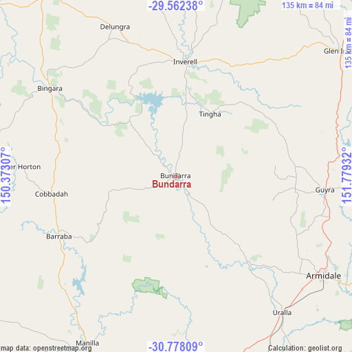
Bundarra GPS coordinates[2]
30° 10' 19.596" South, 151° 4' 34.284" East
| Map corner | latitude | longitude |
|---|---|---|
| Upper-left | -29.56238°, | 150.37307° |
| Center: | -30.17211°, | 151.07619° |
| Lower-right: | -30.77809°, | 151.77932° |
| Map W x H: | 135.2×135.2 km | = 84×84mi |
| max Lat: | -10.58257° ⇑27.9% North |
| Bundarra: | -30.17211° |
| min Lat: | ⇓72.1% South -43.31423° |
| min Long | Bundarra | max Long |
| 113.53327° | 151.07619° | 153.61246° |
| W 69.2%⇐ | ⇒30.8% E |
Elevation
Elevation of Bundarra is 661 m = 2169 ft, and this is 539 m = 1768 ft above average elevation for this country.
| Max E: |
1715 m = 5627 ft | 2.2% |
| Bundarra | 661 m 2169 ft | |
| Avg. | 122 m = 400 ft | |
Min E: |
-2 m = -7 ft | 97.8% |
See also: Australia elevation on elevation.city.
Geographical zone
Bundarra is located in South temperate zone (between Tropic of Capricorn and the Antarctic Circle). Distance of this Southern Tropic circle is 748.9 km =465.3 mi to North.| Distance of | km | miles | from Bundarra |
|---|---|---|---|
| Equator | 3354.8 | 2084.6 | to North |
| Tropic Capricorn | 748.9 | 465.3 | to North |
| Antarctic Circle | 4046.3 | 2514.3 | to South |
| South Pole | 6652.2 | 4133.5 | to South |


Nearby cities:
15 places around Bundarra: (largest is in red/bold)
• Armidale
67.4 km =41.9 mi,  122°
122°
• Attunga
87.1 km =54.1 mi,  194°
194°
• Barraba
50.7 km =31.5 mi,  242°
242°
• Bingara
59.1 km =36.7 mi,  304°
304°
• Delungra
62.3 km =38.7 mi,  337°
337°
• Gilgai
35.7 km =22.2 mi,  6°
6°
• Glen Innes
80.2 km =49.8 mi,  52°
52°
• Guyra
57.1 km =35.5 mi,  94°
94°
• Inverell
44.4 km =27.6 mi,  4°
4°
• Invergowrie
56 km =34.8 mi,  132°
132°
• Manilla
72.5 km =45 mi,  208°
208°
• Moore
92.6 km =57.5 mi, 189°
• Tingha
27.4 km =17 mi,  28°
28°
• Uralla
66.2 km =41.1 mi,  142°
142°
• Warialda
85 km =52.8 mi,  325°
325°
Sources, notices
• [Note1] Compared only with cities in Australia existing in our database
• [Src1] Map data: © OpenStreetMap contributors (CC-BY-SA)
• [Src2] Other city data from geonames.org with taken over terms of usage.
• [Src3] Geographical zone / Annual Mean Temperature by Robert A. Rohde @ Wikipedia
