East Jindabyne geodata
East Jindabyne (New South Wales) is a section of populated place; located in Australia in Australia/Sydney (GMT+11) time zone. With population of 1,001 people, there are 3815 cities with bigger population in this country. Compared to other cities in Australia, 79.7% of cities are located further ↑North; 52% of cities are located further ←West and 99.6% of cities have lower elevation than East Jindabyne. Note1


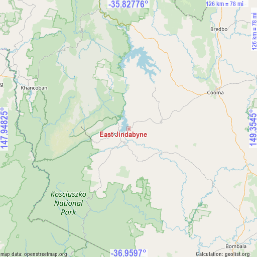
East Jindabyne GPS coordinates[2]
36° 23' 44.844" South, 148° 39' 4.932" East
| Map corner | latitude | longitude |
|---|---|---|
| Upper-left | -35.82776°, | 147.94825° |
| Center: | -36.39579°, | 148.65137° |
| Lower-right: | -36.9597°, | 149.3545° |
| Map W x H: | 125.9×125.9 km | = 78.2×78.2mi |
| max Lat: | -10.58257° ⇑79.7% North |
| East Jindabyne: | -36.39579° |
| min Lat: | ⇓20.3% South -43.31423° |
| min Long | East Jindabyne | max Long |
| 113.53327° | 148.65137° | 153.61246° |
| W 52%⇐ | ⇒48% E |
Elevation
Elevation of East Jindabyne is 961 m = 3153 ft, and this is 839 m = 2753 ft above average elevation for this country.
| Max E: |
1715 m = 5627 ft | 0.40000000000001% |
| East Jindabyne | 961 m 3153 ft | |
| Avg. | 122 m = 400 ft | |
Min E: |
-2 m = -7 ft | 99.6% |
See also: Australia elevation on elevation.city.
Geographical zone
East Jindabyne is located in South temperate zone (between Tropic of Capricorn and the Antarctic Circle). Distance of this Southern Tropic circle is 1440.9 km =895.3 mi to North.| Distance of | km | miles | from East Jindabyne |
|---|---|---|---|
| Equator | 4046.8 | 2514.6 | to North |
| Tropic Capricorn | 1440.9 | 895.3 | to North |
| Antarctic Circle | 3354.3 | 2084.3 | to South |
| South Pole | 5960.2 | 3703.5 | to South |


Nearby cities:
15 places around East Jindabyne: (largest is in red/bold)
• Batlow
107.4 km =66.7 mi,  335°
335°
• Bemboka
86.2 km =53.6 mi,  107°
107°
• Berridale
16.1 km =10 mi,  78°
78°
• Bombala
77.6 km =48.2 mi,  137°
137°
• Burra
106.3 km =66.1 mi,  28°
28°
• Candelo
101.9 km =63.3 mi, 113°
• Cooma
46 km =28.6 mi,  67°
67°
• Corryong
70.6 km =43.9 mi,  288°
288°
• Crackenback
14.5 km =9 mi,  248°
248°
• Jindabyne
3.5 km =2.2 mi,  226°
226°
• Kosciuszko National Park
21.1 km =13.1 mi,  313°
313°
• Michelago
88.6 km =55.1 mi, 31°
• Moonbah
13.1 km =8.1 mi,  223°
223°
• Royalla
107.6 km =66.9 mi,  24°
24°
• Tumbarumba
89.6 km =55.7 mi,  320°
320°
Sources, notices
• [Note1] Compared only with cities in Australia existing in our database
• [Src1] Map data: © OpenStreetMap contributors (CC-BY-SA)
• [Src2] Other city data from geonames.org with taken over terms of usage.
• [Src3] Geographical zone / Annual Mean Temperature by Robert A. Rohde @ Wikipedia
