Corryong geodata
Corryong (Victoria) is a populated place; located in Australia in Australia/Melbourne (GMT+11) time zone. With population of 1,268 people, there are 3506 cities with bigger population in this country. Compared to other cities in Australia, 79.1% of cities are located further ↑North; 50.8% of cities are located further ←West and 88.4% of cities have lower elevation than Corryong. Note1


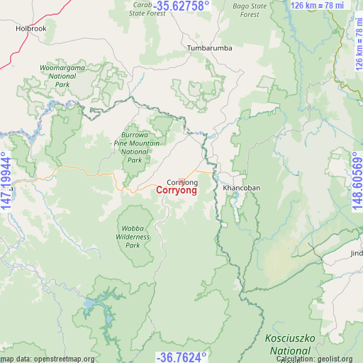
Corryong GPS coordinates[2]
36° 11' 49.38" South, 147° 54' 9.216" East
| Map corner | latitude | longitude |
|---|---|---|
| Upper-left | -35.62758°, | 147.19944° |
| Center: | -36.19705°, | 147.90256° |
| Lower-right: | -36.7624°, | 148.60569° |
| Map W x H: | 126.2×126.2 km | = 78.4×78.4mi |
| max Lat: | -10.58257° ⇑79.1% North |
| Corryong: | -36.19705° |
| min Lat: | ⇓20.9% South -43.31423° |
| min Long | Corryong | max Long |
| 113.53327° | 147.90256° | 153.61246° |
| W 50.8%⇐ | ⇒49.2% E |
Elevation
Elevation of Corryong is 323 m = 1060 ft, and this is 201 m = 659 ft above average elevation for this country.
| Max E: |
1715 m = 5627 ft | 11.6% |
| Corryong | 323 m 1060 ft | |
| Avg. | 122 m = 400 ft | |
Min E: |
-2 m = -7 ft | 88.4% |
See also: Australia elevation on elevation.city.
Geographical zone
Corryong is located in South temperate zone (between Tropic of Capricorn and the Antarctic Circle). Distance of this Southern Tropic circle is 1418.8 km =881.6 mi to North.| Distance of | km | miles | from Corryong |
|---|---|---|---|
| Equator | 4024.7 | 2500.8 | to North |
| Tropic Capricorn | 1418.8 | 881.6 | to North |
| Antarctic Circle | 3376.4 | 2098 | to South |
| South Pole | 5982.3 | 3717.2 | to South |


Nearby cities:
15 places around Corryong: (largest is in red/bold)
• Baranduda
85.1 km =52.9 mi,  270°
270°
• Batlow
78.5 km =48.8 mi,  16°
16°
• Berridale
85 km =52.8 mi,  102°
102°
• Bonegilla
80.7 km =50.1 mi, 274°
• Crackenback
60.1 km =37.3 mi,  117°
117°
• East Jindabyne
70.6 km =43.9 mi,  108°
108°
• Holbrook
74.8 km =46.5 mi,  315°
315°
• Jindabyne
69 km =42.9 mi, 110°
• Kosciuszko National Park
52.5 km =32.6 mi, 98°
• Moonbah
66.2 km =41.1 mi, 118°
• Table Top
85.1 km =52.9 mi,  287°
287°
• Tallangatta
65.1 km =40.5 mi, 267°
• Tangambalanga
78.6 km =48.8 mi, 265°
• Thurgoona
83.4 km =51.8 mi,  282°
282°
• Tumbarumba
47.6 km =29.6 mi,  11°
11°
Sources, notices
• [Note1] Compared only with cities in Australia existing in our database
• [Src1] Map data: © OpenStreetMap contributors (CC-BY-SA)
• [Src2] Other city data from geonames.org with taken over terms of usage.
• [Src3] Geographical zone / Annual Mean Temperature by Robert A. Rohde @ Wikipedia
