Laçın geodata
Laçın is a seat of a first-order administrative division; located in Azerbaijan in Asia/Baku (GMT+4) time zone. With population of 2,300 people, there are 140 cities with bigger population in this country. Compared to other cities in Azerbaijan, 80% of cities are located further ↑North; 72.4% of cities are located further →East and 86.5% of cities have lower elevation than Laçın. Note1


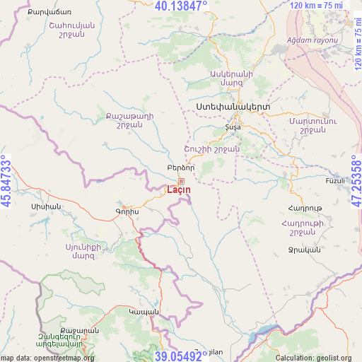
Laçın GPS coordinates[2]
39° 35' 55.716" North, 46° 33' 1.62" East
| Map corner | latitude | longitude |
|---|---|---|
| Upper-left | 40.13847°, | 45.84733° |
| Center: | 39.59881°, | 46.55045° |
| Lower-right: | 39.05492°, | 47.25358° |
| Map W x H: | 120.5×120.5 km | = 74.9×74.9mi |
| max Lat: | 41.75259° ⇑80% North |
| Laçın: | 39.59881° |
| min Lat: | ⇓20% South 38.45598° |
| min Long | Laçın | max Long |
| 44.84846° | 46.55045° | 50.84003° |
| W 27.6%⇐ | ⇒72.4% E |
Elevation
Elevation of Laçın is 889 m = 2917 ft, and this is 506 m = 1660 ft above average elevation for this country.
| Max E: |
2211 m = 7254 ft | 13.5% |
| Laçın | 889 m 2917 ft | |
| Avg. | 383 m = 1257 ft | |
Min E: |
-26 m = -85 ft | 86.5% |
See also: Azerbaijan elevation on elevation.city.
Geographical zone
Laçın is located in North temperate zone (between Tropic of Cancer and the Arctic Circle). Distance of this Northern Tropic circle is 1797.1 km =1116.7 mi to South.| Distance of | km | miles | from Laçın |
|---|---|---|---|
| North Pole | 5604.1 | 3482.2 | to North |
| Arctic Circle | 2998.2 | 1863 | to North |
| Tropic Cancer | 1797.1 | 1116.7 | to South |
| Equator | 4403 | 2735.9 | to South |


Nearby cities:
15 places around Laçın: (largest is in red/bold)
• Askyaran
44.8 km =27.8 mi,  32°
32°
• Ağdam
54.2 km =33.7 mi,  36°
36°
• Fizuli
51 km =31.7 mi,  89°
89°
• Hadrut
42.2 km =26.2 mi,  101°
101°
• Jebrail
46.6 km =29 mi,  118°
118°
• Mincivan
64.9 km =40.3 mi,  166°
166°
• Novyy Karanlug
52.7 km =32.7 mi,  65°
65°
• Qubadlı
28.4 km =17.6 mi, 174°
• Qırmızı Bazar
35.4 km =22 mi,  75°
75°
• Shushi
24.8 km =15.4 mi, 43°
• Vank
50.5 km =31.4 mi,  359°
359°
• Xankandi
29.9 km =18.6 mi, 35°
• Xocalı
40.5 km =25.2 mi, 30°
• Zangilan
58 km =36 mi, 170°
• İstisu
63.5 km =39.5 mi,  307°
307°
Sources, notices
• [Note1] Compared only with cities in Azerbaijan existing in our database
• [Src1] Map data: © OpenStreetMap contributors (CC-BY-SA)
• [Src2] Other city data from geonames.org with taken over terms of usage.
• [Src3] Geographical zone / Annual Mean Temperature by Robert A. Rohde @ Wikipedia
