Xankandi geodata
Xankandi (Xankǝndi) is a populated place; located in Azerbaijan in Asia/Baku (GMT+4) time zone. With population of 53,100 people, there are 12 cities with bigger population in this country. Compared to other cities in Azerbaijan, 73.5% of cities are located further ↑North; 68.1% of cities are located further →East and 83.8% of cities have lower elevation than Xankandi. Note1


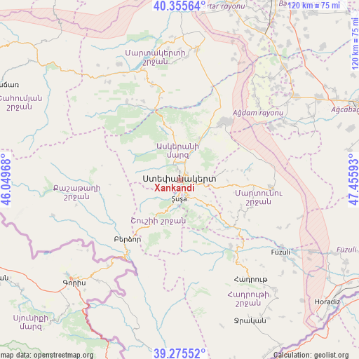
Xankandi GPS coordinates[2]
39° 49' 3.72" North, 46° 45' 10.08" East
| Map corner | latitude | longitude |
|---|---|---|
| Upper-left | 40.35564°, | 46.04968° |
| Center: | 39.8177°, | 46.7528° |
| Lower-right: | 39.27552°, | 47.45593° |
| Map W x H: | 120.1×120.1 km | = 74.6×74.6mi |
| max Lat: | 41.75259° ⇑73.5% North |
| Xankandi: | 39.8177° |
| min Lat: | ⇓26.5% South 38.45598° |
| min Long | Xankandi | max Long |
| 44.84846° | 46.7528° | 50.84003° |
| W 31.9%⇐ | ⇒68.1% E |
Elevation
Elevation of Xankandi is 850 m = 2789 ft, and this is 467 m = 1532 ft above average elevation for this country.
| Max E: |
2211 m = 7254 ft | 16.2% |
| Xankandi | 850 m 2789 ft | |
| Avg. | 383 m = 1257 ft | |
Min E: |
-26 m = -85 ft | 83.8% |
See also: Xankandi elevation on elevation.city.
Geographical zone
Xankandi is located in North temperate zone (between Tropic of Cancer and the Arctic Circle). Distance of this Northern Tropic circle is 1821.4 km =1131.8 mi to South.| Distance of | km | miles | from Xankandi |
|---|---|---|---|
| North Pole | 5579.7 | 3467.1 | to North |
| Arctic Circle | 2973.9 | 1847.9 | to North |
| Tropic Cancer | 1821.4 | 1131.8 | to South |
| Equator | 4427.3 | 2751 | to South |


Nearby cities:
15 places around Xankandi: (largest is in red/bold)
• Askyaran
15.1 km =9.4 mi,  26°
26°
• Avşar
59.8 km =37.2 mi,  73°
73°
• Ağdam
24.3 km =15.1 mi,  37°
37°
• Fizuli
41.3 km =25.7 mi,  125°
125°
• Hadrut
40.8 km =25.4 mi,  144°
144°
• Jebrail
52.2 km =32.4 mi,  153°
153°
• Laçın
29.9 km =18.6 mi,  215°
215°
• Martakert
44.1 km =27.4 mi,  7°
7°
• Novyy Karanlug
30.8 km =19.1 mi,  94°
94°
• Qubadlı
54.6 km =33.9 mi,  195°
195°
• Qırmızı Bazar
23.1 km =14.4 mi, 132°
• Shushi
6.4 km =4 mi,  182°
182°
• Terter
60.2 km =37.4 mi, 14°
• Vank
31.6 km =19.6 mi,  325°
325°
• Xocalı
11.1 km =6.9 mi,  16°
16°
In other languages:
- In Spanish: Khankendi
- In France: Khankendi
- In German: Chankändi
- In Russian: Степанакерт
Sources, notices
• [Note1] Compared only with cities in Azerbaijan existing in our database
• [Src1] Map data: © OpenStreetMap contributors (CC-BY-SA)
• [Src2] Other city data from geonames.org with taken over terms of usage.
• [Src3] Geographical zone / Annual Mean Temperature by Robert A. Rohde @ Wikipedia
