Bogra geodata
Bogra (Rajshahi Division) is a populated place; located in Bangladesh in Asia/Dhaka (GMT+6) time zone. With population of 210,000 people, there are 17 cities with bigger population in this country. Compared to other cities in Bangladesh, 81.2% of cities are located further ↓South; 75.2% of cities are located further →East and 84.6% of cities have lower elevation than Bogra. Note1
Administrative division(s):
- Level 1: Rajshahi Division
- Level 2: Bogra
- Level 3: Bogra
- Level 4: Paurashava


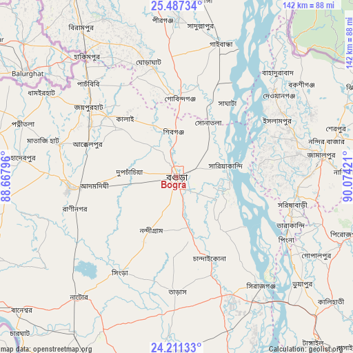
Bogra GPS coordinates[2]
24° 51' 3.528" North, 89° 22' 15.888" East
| Map corner | latitude | longitude |
|---|---|---|
| Upper-left | 25.48734°, | 88.66796° |
| Center: | 24.85098°, | 89.37108° |
| Lower-right: | 24.21133°, | 90.07421° |
| Map W x H: | 141.9×141.9 km | = 88.2×88.2mi |
| max Lat: | 26.33338° ⇑18.8% North |
| Bogra: | 24.85098° |
| min Lat: | ⇓81.2% South 20.85829° |
| min Long | Bogra | max Long |
| 88.15638° | 89.37108° | 92.29773° |
| W 24.8%⇐ | ⇒75.2% E |
Elevation
Elevation of Bogra is 26 m = 85 ft, and this is 8.1 m = 27 ft above average elevation for this country.
| Max E: |
79 m = 259 ft | 15.4% |
| Bogra | 26 m 85 ft | |
| Avg. | 17.9 m = 59 ft | |
Min E: |
2 m = 7 ft | 84.6% |
See also: Bogra elevation on elevation.city.
Geographical zone
Bogra is located in North temperate zone (between Tropic of Cancer and the Arctic Circle). Distance of this Northern Tropic circle is 157.3 km =97.7 mi to South.| Distance of | km | miles | from Bogra |
|---|---|---|---|
| North Pole | 7243.9 | 4501.1 | to North |
| Arctic Circle | 4638 | 2881.9 | to North |
| Tropic Cancer | 157.3 | 97.7 | to South |
| Equator | 2763.2 | 1717 | to South |


Nearby cities:
15 places around Bogra: (largest is in red/bold)
• Chilmāri
84 km =52.2 mi,  21°
21°
• Gaibandha
56 km =34.8 mi, 18°
• Ishurdi
86.1 km =53.5 mi,  201°
201°
• Jamālpur
58.7 km =36.5 mi,  82°
82°
• Joypur Hāt
44.5 km =27.7 mi,  308°
308°
• Mahasthangarh
12.6 km =7.8 mi,  346°
346°
• Natore
62.5 km =38.8 mi,  218°
218°
• Paharpur
44.4 km =27.6 mi,  296°
296°
• Puthia
76.5 km =47.5 mi,  225°
225°
• Pār Naogaon
42.9 km =26.7 mi,  263°
263°
• Sarishābāri
47.8 km =29.7 mi,  103°
103°
• Sherpur
67.8 km =42.1 mi,  74°
74°
• Shibganj
17.4 km =10.8 mi,  343°
343°
• Shāhzādpur
78.4 km =48.7 mi,  162°
162°
• Sirajganj
55.4 km =34.4 mi,  142°
142°
Sources, notices
• [Note1] Compared only with cities in Bangladesh existing in our database
• [Src1] Map data: © OpenStreetMap contributors (CC-BY-SA)
• [Src2] Other city data from geonames.org with taken over terms of usage.
• [Src3] Geographical zone / Annual Mean Temperature by Robert A. Rohde @ Wikipedia
