Burhānuddin geodata
Burhānuddin (Barisāl) is a populated place; located in Bangladesh in Asia/Dhaka (GMT+6) time zone. With population of 45,670 people, there are 68 cities with bigger population in this country. Compared to other cities in Bangladesh, 89.7% of cities are located further ↑North; 73.5% of cities are located further ←West and 88.9% of cities have higher elevation than Burhānuddin. Note1


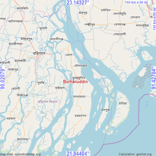
Burhānuddin GPS coordinates[2]
22° 29' 42.648" North, 90° 43' 26.076" East
| Map corner | latitude | longitude |
|---|---|---|
| Upper-left | 23.14327°, | 90.02079° |
| Center: | 22.49518°, | 90.72391° |
| Lower-right: | 21.84404°, | 91.42704° |
| Map W x H: | 144.5×144.5 km | = 89.8×89.8mi |
| max Lat: | 26.33338° ⇑89.7% North |
| Burhānuddin: | 22.49518° |
| min Lat: | ⇓10.3% South 20.85829° |
| min Long | Burhānuddin | max Long |
| 88.15638° | 90.72391° | 92.29773° |
| W 73.5%⇐ | ⇒26.5% E |
Elevation
Elevation of Burhānuddin is 9 m = 30 ft, and this is 8.9 m = 29 ft below average elevation for this country.
| Max E: |
79 m = 259 ft | 88.9% |
| Avg. | 17.9 m = 59 ft | |
| Burhānuddin | 9 m = 30 ft | |
Min E: |
2 m = 7 ft | 11.1% |
See also: Burhānuddin elevation on elevation.city.
Geographical zone
Burhānuddin is located in North Torrid zone (between Equator and Tropic of Cancer). Distance of this Northern Tropic circle is 104.7 km =65.1 mi to North.| Distance of | km | miles | from Burhānuddin |
|---|---|---|---|
| North Pole | 7505.8 | 4663.9 | to North |
| Arctic Circle | 4899.9 | 3044.7 | to North |
| Tropic Cancer | 104.7 | 65.1 | to North |
| Equator | 2501.2 | 1554.2 | to South |


Nearby cities:
15 places around Burhānuddin: (largest is in red/bold)
• Barisāl
43.2 km =26.8 mi,  302°
302°
• Bhola
22.9 km =14.2 mi,  339°
339°
• Bhāndāria
67.9 km =42.2 mi,  269°
269°
• Gaurnadi
73.9 km =45.9 mi,  316°
316°
• Hājīganj
85.2 km =52.9 mi,  9°
9°
• Lakshmīpur
51.1 km =31.8 mi, 12°
• Lālmohan
17.6 km =10.9 mi,  175°
175°
• Mathba
82 km =51 mi,  253°
253°
• Mehendiganj
41.6 km =25.8 mi,  331°
331°
• Nālchiti
49 km =30.4 mi,  288°
288°
• Pirojpur
77.5 km =48.2 mi,  276°
276°
• Rāipur
60.6 km =37.7 mi,  4°
4°
• Rāmganj
68.5 km =42.6 mi, 10°
• Sandwīp
75.1 km =46.7 mi,  88°
88°
• Uttar Char Fasson
29.9 km =18.6 mi, 182°
Sources, notices
• [Note1] Compared only with cities in Bangladesh existing in our database
• [Src1] Map data: © OpenStreetMap contributors (CC-BY-SA)
• [Src2] Other city data from geonames.org with taken over terms of usage.
• [Src3] Geographical zone / Annual Mean Temperature by Robert A. Rohde @ Wikipedia
