Raojān geodata
Raojān (Chittagong) is a populated place; located in Bangladesh in Asia/Dhaka (GMT+6) time zone. With population of 25,708 people, there are 101 cities with bigger population in this country. Compared to other cities in Bangladesh, 88% of cities are located further ↑North; 94.9% of cities are located further ←West and 88.9% of cities have higher elevation than Raojān. Note1
Administrative division(s):
- Level 1: Chittagong
- Level 2: Chittagong
- Level 3: Raozan Upazila
- Level 4: Sultanpur


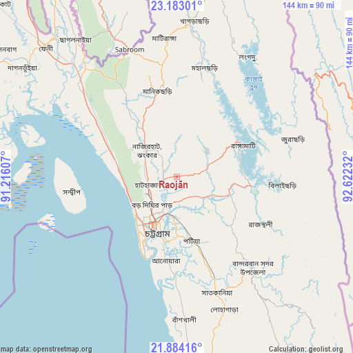
Raojān GPS coordinates[2]
22° 32' 6.396" North, 91° 55' 9.084" East
| Map corner | latitude | longitude |
|---|---|---|
| Upper-left | 23.18301°, | 91.21607° |
| Center: | 22.53511°, | 91.91919° |
| Lower-right: | 21.88416°, | 92.62232° |
| Map W x H: | 144.4×144.4 km | = 89.7×89.7mi |
| max Lat: | 26.33338° ⇑88% North |
| Raojān: | 22.53511° |
| min Lat: | ⇓12% South 20.85829° |
| min Long | Raojān | max Long |
| 88.15638° | 91.91919° | 92.29773° |
| W 94.9%⇐ | ⇒5.1% E |
Elevation
Elevation of Raojān is 9 m = 30 ft, and this is 8.9 m = 29 ft below average elevation for this country.
| Max E: |
79 m = 259 ft | 88.9% |
| Avg. | 17.9 m = 59 ft | |
| Raojān | 9 m = 30 ft | |
Min E: |
2 m = 7 ft | 11.1% |
See also: Bangladesh elevation on elevation.city.
Geographical zone
Raojān is located in North Torrid zone (between Equator and Tropic of Cancer). Distance of this Northern Tropic circle is 100.2 km =62.3 mi to North.| Distance of | km | miles | from Raojān |
|---|---|---|---|
| North Pole | 7501.4 | 4661.2 | to North |
| Arctic Circle | 4895.5 | 3041.9 | to North |
| Tropic Cancer | 100.2 | 62.3 | to North |
| Equator | 2505.7 | 1557 | to South |


Nearby cities:
15 places around Raojān: (largest is in red/bold)
• Bibir Hat
21.1 km =13.1 mi,  321°
321°
• Burhānuddin
122.9 km =76.4 mi,  267°
267°
• Bāndarban
48.8 km =30.3 mi,  140°
140°
• Chhāgalnāiya
68.7 km =42.7 mi, 322°
• Chittagong
23.6 km =14.7 mi,  202°
202°
• Cox’s Bāzār
122.2 km =75.9 mi,  175°
175°
• Feni
75.6 km =47 mi,  314°
314°
• Khagrachhari
63.9 km =39.7 mi,  4°
4°
• Lakshmīpur
120.6 km =74.9 mi,  292°
292°
• Lākshām
113.2 km =70.3 mi, 313°
• Lālmohan
123.5 km =76.7 mi,  259°
259°
• Manikchari
34.8 km =21.6 mi,  346°
346°
• Patiya
27.3 km =17 mi,  167°
167°
• Sandwīp
47.7 km =29.6 mi, 267°
• Sātkania
52.7 km =32.7 mi, 165°
Sources, notices
• [Note1] Compared only with cities in Bangladesh existing in our database
• [Src1] Map data: © OpenStreetMap contributors (CC-BY-SA)
• [Src2] Other city data from geonames.org with taken over terms of usage.
• [Src3] Geographical zone / Annual Mean Temperature by Robert A. Rohde @ Wikipedia
