Sandwīp geodata
Sandwīp (Chittagong) is a populated place; located in Bangladesh in Asia/Dhaka (GMT+6) time zone. With population of 52,152 people, there are 59 cities with bigger population in this country. Compared to other cities in Bangladesh, 88.9% of cities are located further ↑North; 87.2% of cities are located further ←West and 98.3% of cities have higher elevation than Sandwīp. Note1
Administrative division(s):
- Level 1: Chittagong
- Level 2: Chittagong
- Level 3: Sandwip
- Level 4: Bauria


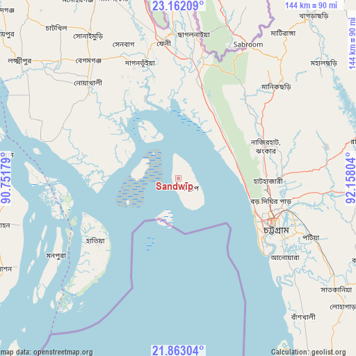
Sandwīp GPS coordinates[2]
22° 30' 50.724" North, 91° 27' 17.676" East
| Map corner | latitude | longitude |
|---|---|---|
| Upper-left | 23.16209°, | 90.75179° |
| Center: | 22.51409°, | 91.45491° |
| Lower-right: | 21.86304°, | 92.15804° |
| Map W x H: | 144.4×144.4 km | = 89.7×89.7mi |
| max Lat: | 26.33338° ⇑88.9% North |
| Sandwīp: | 22.51409° |
| min Lat: | ⇓11.1% South 20.85829° |
| min Long | Sandwīp | max Long |
| 88.15638° | 91.45491° | 92.29773° |
| W 87.2%⇐ | ⇒12.8% E |
Elevation
Elevation of Sandwīp is 7 m = 23 ft, and this is 10.9 m = 36 ft below average elevation for this country.
| Max E: |
79 m = 259 ft | 98.3% |
| Avg. | 17.9 m = 59 ft | |
| Sandwīp | 7 m = 23 ft | |
Min E: |
2 m = 7 ft | 1.7% |
See also: Sandwīp elevation on elevation.city.
Geographical zone
Sandwīp is located in North Torrid zone (between Equator and Tropic of Cancer). Distance of this Northern Tropic circle is 102.6 km =63.8 mi to North.| Distance of | km | miles | from Sandwīp |
|---|---|---|---|
| North Pole | 7503.7 | 4662.6 | to North |
| Arctic Circle | 4897.8 | 3043.4 | to North |
| Tropic Cancer | 102.6 | 63.8 | to North |
| Equator | 2503.3 | 1555.5 | to South |


Nearby cities:
15 places around Sandwīp: (largest is in red/bold)
• Bhola
85.4 km =53.1 mi,  283°
283°
• Bibir Hat
39.3 km =24.4 mi,  61°
61°
• Burhānuddin
75.1 km =46.7 mi,  268°
268°
• Bāndarban
86.2 km =53.6 mi,  114°
114°
• Chhāgalnāiya
57.1 km =35.5 mi,  5°
5°
• Chittagong
43.4 km =27 mi,  116°
116°
• Feni
55.9 km =34.7 mi,  353°
353°
• Khagrachhari
84.5 km =52.5 mi,  38°
38°
• Lakshmīpur
80 km =49.7 mi,  306°
306°
• Lālmohan
76.3 km =47.4 mi,  255°
255°
• Manikchari
53.7 km =33.4 mi,  47°
47°
• Patiya
59.1 km =36.7 mi, 114°
• Raojān
47.7 km =29.6 mi,  87°
87°
• Sātkania
78.2 km =48.6 mi,  128°
128°
• Uttar Char Fasson
82.7 km =51.4 mi,  247°
247°
Sources, notices
• [Note1] Compared only with cities in Bangladesh existing in our database
• [Src1] Map data: © OpenStreetMap contributors (CC-BY-SA)
• [Src2] Other city data from geonames.org with taken over terms of usage.
• [Src3] Geographical zone / Annual Mean Temperature by Robert A. Rohde @ Wikipedia
