Bhāndāria geodata
Bhāndāria (Barisāl) is a populated place; located in Bangladesh in Asia/Dhaka (GMT+6) time zone. With population of 30,219 people, there are 99 cities with bigger population in this country. Compared to other cities in Bangladesh, 90.6% of cities are located further ↑North; 53% of cities are located further →East and 65% of cities have higher elevation than Bhāndāria. Note1
Administrative division(s):
- Level 1: Barisāl
- Level 2: Pirojpur
- Level 3: Bhandaria Upazila
- Level 4: Bhandaria


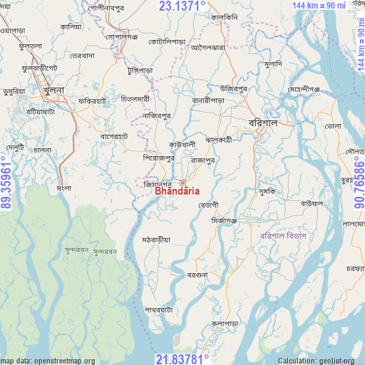
Bhāndāria GPS coordinates[2]
22° 29' 20.328" North, 90° 3' 45.828" East
| Map corner | latitude | longitude |
|---|---|---|
| Upper-left | 23.1371°, | 89.35961° |
| Center: | 22.48898°, | 90.06273° |
| Lower-right: | 21.83781°, | 90.76586° |
| Map W x H: | 144.5×144.5 km | = 89.8×89.8mi |
| max Lat: | 26.33338° ⇑90.6% North |
| Bhāndāria: | 22.48898° |
| min Lat: | ⇓9.4% South 20.85829° |
| min Long | Bhāndāria | max Long |
| 88.15638° | 90.06273° | 92.29773° |
| W 47%⇐ | ⇒53% E |
Elevation
Elevation of Bhāndāria is 13 m = 43 ft, and this is 4.9 m = 16 ft below average elevation for this country.
| Max E: |
79 m = 259 ft | 65% |
| Avg. | 17.9 m = 59 ft | |
| Bhāndāria | 13 m = 43 ft | |
Min E: |
2 m = 7 ft | 35% |
See also: Bangladesh elevation on elevation.city.
Geographical zone
Bhāndāria is located in North Torrid zone (between Equator and Tropic of Cancer). Distance of this Northern Tropic circle is 105.4 km =65.5 mi to North.| Distance of | km | miles | from Bhāndāria |
|---|---|---|---|
| North Pole | 7506.5 | 4664.3 | to North |
| Arctic Circle | 4900.6 | 3045.1 | to North |
| Tropic Cancer | 105.4 | 65.5 | to North |
| Equator | 2500.5 | 1553.7 | to South |


Nearby cities:
15 places around Bhāndāria: (largest is in red/bold)
• Bagerhat
33.5 km =20.8 mi,  303°
303°
• Barisāl
39.7 km =24.7 mi,  52°
52°
• Bhola
63.6 km =39.5 mi,  69°
69°
• Burhānuddin
67.9 km =42.2 mi,  89°
89°
• Gaurnadi
56.4 km =35 mi,  17°
17°
• Khulna
62.3 km =38.7 mi, 304°
• Lālmohan
71.3 km =44.3 mi,  103°
103°
• Mathba
25 km =15.5 mi,  205°
205°
• Mehendiganj
60.5 km =37.6 mi, 52°
• Morrelgonj
21.6 km =13.4 mi,  260°
260°
• Nālchiti
27.1 km =16.8 mi, 52°
• Phultala
62 km =38.5 mi,  294°
294°
• Pirojpur
13.5 km =8.4 mi,  318°
318°
• Sarankhola
34.3 km =21.3 mi,  234°
234°
• Tungipāra
48.5 km =30.1 mi,  340°
340°
Sources, notices
• [Note1] Compared only with cities in Bangladesh existing in our database
• [Src1] Map data: © OpenStreetMap contributors (CC-BY-SA)
• [Src2] Other city data from geonames.org with taken over terms of usage.
• [Src3] Geographical zone / Annual Mean Temperature by Robert A. Rohde @ Wikipedia
