Barisāl geodata
Barisāl is a seat of a first-order administrative division; located in Bangladesh in Asia/Dhaka (GMT+6) time zone. With population of 202,242 people, there are 19 cities with bigger population in this country. Compared to other cities in Bangladesh, 82.9% of cities are located further ↑North; 61.5% of cities are located further ←West and 81.2% of cities have higher elevation than Barisāl. Note1
Administrative division(s):
- Level 1: Barisāl
- Level 2: Barisal
- Level 3: Barisal Sadar Upazila
- Level 4: BARISAL SMA


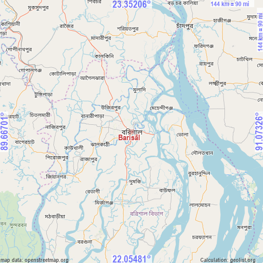
Barisāl GPS coordinates[2]
22° 42' 17.892" North, 90° 22' 12.468" East
| Map corner | latitude | longitude |
|---|---|---|
| Upper-left | 23.35206°, | 89.66701° |
| Center: | 22.70497°, | 90.37013° |
| Lower-right: | 22.05481°, | 91.07326° |
| Map W x H: | 144.2×144.2 km | = 89.6×89.6mi |
| max Lat: | 26.33338° ⇑82.9% North |
| Barisāl: | 22.70497° |
| min Lat: | ⇓17.1% South 20.85829° |
| min Long | Barisāl | max Long |
| 88.15638° | 90.37013° | 92.29773° |
| W 61.5%⇐ | ⇒38.5% E |
Elevation
Elevation of Barisāl is 10 m = 33 ft, and this is 7.9 m = 26 ft below average elevation for this country.
| Max E: |
79 m = 259 ft | 81.2% |
| Avg. | 17.9 m = 59 ft | |
| Barisāl | 10 m = 33 ft | |
Min E: |
2 m = 7 ft | 18.8% |
See also: Barisāl elevation on elevation.city.
Geographical zone
Barisāl is located in North Torrid zone (between Equator and Tropic of Cancer). Distance of this Northern Tropic circle is 81.4 km =50.6 mi to North.| Distance of | km | miles | from Barisāl |
|---|---|---|---|
| North Pole | 7482.5 | 4649.4 | to North |
| Arctic Circle | 4876.6 | 3030.2 | to North |
| Tropic Cancer | 81.4 | 50.6 | to North |
| Equator | 2524.6 | 1568.7 | to South |


Nearby cities:
15 places around Barisāl: (largest is in red/bold)
• Bagerhat
59.6 km =37 mi,  264°
264°
• Bhola
28.2 km =17.5 mi,  93°
93°
• Bhāndāria
39.7 km =24.7 mi,  232°
232°
• Burhānuddin
43.2 km =26.8 mi,  122°
122°
• Gaurnadi
33.4 km =20.8 mi,  333°
333°
• Lakshmīpur
54.1 km =33.6 mi,  60°
60°
• Lālmohan
55.6 km =34.5 mi,  137°
137°
• Mehendiganj
20.9 km =13 mi,  51°
51°
• Morrelgonj
59.6 km =37 mi,  242°
242°
• Mādārīpur
54.4 km =33.8 mi,  342°
342°
• Nālchiti
12.6 km =7.8 mi, 233°
• Pirojpur
42.9 km =26.7 mi,  251°
251°
• Pālang
57.1 km =35.5 mi,  358°
358°
• Rāipur
55.2 km =34.3 mi, 47°
• Tungipāra
52.5 km =32.6 mi,  294°
294°
Sources, notices
• [Note1] Compared only with cities in Bangladesh existing in our database
• [Src1] Map data: © OpenStreetMap contributors (CC-BY-SA)
• [Src2] Other city data from geonames.org with taken over terms of usage.
• [Src3] Geographical zone / Annual Mean Temperature by Robert A. Rohde @ Wikipedia
