Aarschot geodata
Aarschot (Flanders) is a populated place; located in Belgium in Europe/Brussels (GMT+2) time zone. With population of 27,656 people, there are 69 cities with bigger population in this country. Compared to other cities in Belgium, 69% of cities are located further ↓South; 59.7% of cities are located further ←West and 79.4% of cities have higher elevation than Aarschot. Note1
Administrative division(s):
- Level 1: Flanders
- Level 2: Provincie Vlaams-Brabant
- Level 3: Arrondissement Leuven
- Level 4: Aarschot


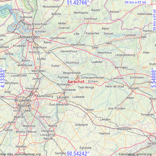
Aarschot GPS coordinates[2]
50° 59' 13.74" North, 4° 50' 13.02" East
| Map corner | latitude | longitude |
|---|---|---|
| Upper-left | 51.42766°, | 4.13383° |
| Center: | 50.98715°, | 4.83695° |
| Lower-right: | 50.54242°, | 5.54008° |
| Map W x H: | 98.4×98.4 km | = 61.1×61.1mi |
| max Lat: | 51.46791° ⇑31% North |
| Aarschot: | 50.98715° |
| min Lat: | ⇓69% South 49.53771° |
| min Long | Aarschot | max Long |
| 2.59368° | 4.83695° | 6.25749° |
| W 59.7%⇐ | ⇒40.3% E |
Elevation
Elevation of Aarschot is 14 m = 46 ft, and this is 85.5 m = 281 ft below average elevation for this country.
| Max E: |
582 m = 1909 ft | 79.4% |
| Avg. | 99.5 m = 326 ft | |
| Aarschot | 14 m = 46 ft | |
Min E: |
1 m = 3 ft | 20.6% |
See also: Belgium elevation on elevation.city.
Geographical zone
Aarschot is located in North temperate zone (between Tropic of Cancer and the Arctic Circle). Distance of this North polar circle is 1731.9 km =1076.2 mi to North.| Distance of | km | miles | from Aarschot |
|---|---|---|---|
| North Pole | 4337.8 | 2695.4 | to North |
| Arctic Circle | 1731.9 | 1076.2 | to North |
| Tropic Cancer | 3063.3 | 1903.4 | to South |
| Equator | 5669.2 | 3522.7 | to South |


Nearby cities:
15 places around Aarschot: (largest is in red/bold)
• Begijnendijk
5.2 km =3.2 mi,  313°
313°
• Bekkevoort
10.6 km =6.6 mi,  119°
119°
• Diest
15 km =9.3 mi,  89°
89°
• Haacht
14 km =8.7 mi,  265°
265°
• Heist-op-den-Berg
12.4 km =7.7 mi,  322°
322°
• Herent
14.6 km =9.1 mi,  233°
233°
• Herselt
7.8 km =4.8 mi,  23°
23°
• Holsbeek
9.2 km =5.7 mi,  217°
217°
• Hulshout
10.2 km =6.3 mi,  341°
341°
• Keerbergen
14.3 km =8.9 mi,  277°
277°
• Lubbeek
11.6 km =7.2 mi,  179°
179°
• Rotselaar
9.2 km =5.7 mi,  245°
245°
• Scherpenheuvel-Zichem
10 km =6.2 mi,  75°
75°
• Tremelo
9 km =5.6 mi, 273°
• Westerlo
12.7 km =7.9 mi,  25°
25°
Sources, notices
• [Note1] Compared only with cities in Belgium existing in our database
• [Src1] Map data: © OpenStreetMap contributors (CC-BY-SA)
• [Src2] Other city data from geonames.org with taken over terms of usage.
• [Src3] Geographical zone / Annual Mean Temperature by Robert A. Rohde @ Wikipedia
