Remicourt geodata
Remicourt (Wallonia) is a populated place; located in Belgium in Europe/Brussels (GMT+2) time zone. With population of 5,050 people, there are 453 cities with bigger population in this country. Compared to other cities in Belgium, 60.8% of cities are located further ↑North; 78% of cities are located further ←West and 70.9% of cities have lower elevation than Remicourt. Note1
Administrative division(s):
- Level 1: Wallonia
- Level 2: Province de Liège
- Level 3: Arrondissement de Waremme
- Level 4: Remicourt


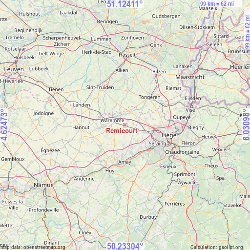
Remicourt GPS coordinates[2]
50° 40' 50.484" North, 5° 19' 40.26" East
| Map corner | latitude | longitude |
|---|---|---|
| Upper-left | 51.12411°, | 4.62473° |
| Center: | 50.68069°, | 5.32785° |
| Lower-right: | 50.23304°, | 6.03098° |
| Map W x H: | 99.1×99.1 km | = 61.6×61.6mi |
| max Lat: | 51.46791° ⇑60.8% North |
| Remicourt: | 50.68069° |
| min Lat: | ⇓39.2% South 49.53771° |
| min Long | Remicourt | max Long |
| 2.59368° | 5.32785° | 6.25749° |
| W 78%⇐ | ⇒22% E |
Elevation
Elevation of Remicourt is 126 m = 413 ft, and this is 26.5 m = 87 ft above average elevation for this country.
| Max E: |
582 m = 1909 ft | 29.1% |
| Remicourt | 126 m 413 ft | |
| Avg. | 99.5 m = 326 ft | |
Min E: |
1 m = 3 ft | 70.9% |
See also: Belgium elevation on elevation.city.
Geographical zone
Remicourt is located in North temperate zone (between Tropic of Cancer and the Arctic Circle). Distance of this North polar circle is 1766 km =1097.3 mi to North.| Distance of | km | miles | from Remicourt |
|---|---|---|---|
| North Pole | 4371.9 | 2716.6 | to North |
| Arctic Circle | 1766 | 1097.3 | to North |
| Tropic Cancer | 3029.2 | 1882.3 | to South |
| Equator | 5635.2 | 3501.5 | to South |


Nearby cities:
15 places around Remicourt: (largest is in red/bold)
• Awans
9.7 km =6 mi,  98°
98°
• Berloz
8.4 km =5.2 mi,  283°
283°
• Crisnée
6.4 km =4 mi,  50°
50°
• Donceel
3.6 km =2.2 mi,  188°
188°
• Engis
12.1 km =7.5 mi,  155°
155°
• Faimes
5.2 km =3.2 mi,  247°
247°
• Fexhe-le-Haut-Clocher
5.3 km =3.3 mi,  108°
108°
• Flémalle-Haute
12.2 km =7.6 mi,  137°
137°
• Geer
10.9 km =6.8 mi,  263°
263°
• Heers
8.3 km =5.2 mi,  347°
347°
• Mons-lez-Liège
12.1 km =7.5 mi,  126°
126°
• Oreye
4.3 km =2.7 mi,  19°
19°
• Verlaine
8.2 km =5.1 mi, 185°
• Villers-le-Bouillet
12.5 km =7.8 mi,  202°
202°
• Waremme
5.4 km =3.4 mi,  290°
290°
Sources, notices
• [Note1] Compared only with cities in Belgium existing in our database
• [Src1] Map data: © OpenStreetMap contributors (CC-BY-SA)
• [Src2] Other city data from geonames.org with taken over terms of usage.
• [Src3] Geographical zone / Annual Mean Temperature by Robert A. Rohde @ Wikipedia
