Donceel geodata
Donceel (Wallonia) is a populated place; located in Belgium in Europe/Brussels (GMT+2) time zone. With population of 2,712 people, there are 517 cities with bigger population in this country. Compared to other cities in Belgium, 64.1% of cities are located further ↑North; 77.8% of cities are located further ←West and 74.7% of cities have lower elevation than Donceel. Note1
Administrative division(s):
- Level 1: Wallonia
- Level 2: Province de Liège
- Level 3: Arrondissement de Waremme
- Level 4: Donceel


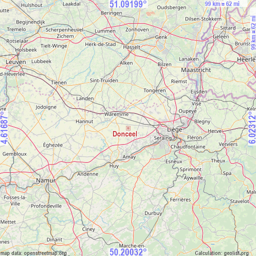
Donceel GPS coordinates[2]
50° 38' 53.772" North, 5° 19' 12" East
| Map corner | latitude | longitude |
|---|---|---|
| Upper-left | 51.09199°, | 4.61687° |
| Center: | 50.64827°, | 5.32° |
| Lower-right: | 50.20032°, | 6.02312° |
| Map W x H: | 99.1×99.1 km | = 61.6×61.6mi |
| max Lat: | 51.46791° ⇑64.1% North |
| Donceel: | 50.64827° |
| min Lat: | ⇓35.9% South 49.53771° |
| min Long | Donceel | max Long |
| 2.59368° | 5.32° | 6.25749° |
| W 77.8%⇐ | ⇒22.2% E |
Elevation
Elevation of Donceel is 146 m = 479 ft, and this is 46.5 m = 153 ft above average elevation for this country.
| Max E: |
582 m = 1909 ft | 25.3% |
| Donceel | 146 m 479 ft | |
| Avg. | 99.5 m = 326 ft | |
Min E: |
1 m = 3 ft | 74.7% |
See also: Belgium elevation on elevation.city.
Geographical zone
Donceel is located in North temperate zone (between Tropic of Cancer and the Arctic Circle). Distance of this North polar circle is 1769.6 km =1099.6 mi to North.| Distance of | km | miles | from Donceel |
|---|---|---|---|
| North Pole | 4375.5 | 2718.8 | to North |
| Arctic Circle | 1769.6 | 1099.6 | to North |
| Tropic Cancer | 3025.6 | 1880 | to South |
| Equator | 5631.6 | 3499.3 | to South |


Nearby cities:
15 places around Donceel: (largest is in red/bold)
• Amay
11.1 km =6.9 mi,  183°
183°
• Awans
10.3 km =6.4 mi,  77°
77°
• Berloz
9.4 km =5.8 mi,  306°
306°
• Crisnée
9.4 km =5.8 mi,  35°
35°
• Engis
9.3 km =5.8 mi,  143°
143°
• Faimes
4.5 km =2.8 mi,  290°
290°
• Fexhe-le-Haut-Clocher
5.9 km =3.7 mi,  71°
71°
• Flémalle-Haute
10.3 km =6.4 mi,  121°
121°
• Geer
10.6 km =6.6 mi,  283°
283°
• Mons-lez-Liège
10.9 km =6.8 mi,  108°
108°
• Oreye
8 km =5 mi,  14°
14°
• Remicourt
3.6 km =2.2 mi, 8°
• Verlaine
4.5 km =2.8 mi, 182°
• Villers-le-Bouillet
9 km =5.6 mi,  208°
208°
• Waremme
7.1 km =4.4 mi,  320°
320°
Sources, notices
• [Note1] Compared only with cities in Belgium existing in our database
• [Src1] Map data: © OpenStreetMap contributors (CC-BY-SA)
• [Src2] Other city data from geonames.org with taken over terms of usage.
• [Src3] Geographical zone / Annual Mean Temperature by Robert A. Rohde @ Wikipedia
