Oreye geodata
Oreye (Wallonia) is a populated place; located in Belgium in Europe/Brussels (GMT+2) time zone. With population of 3,373 people, there are 497 cities with bigger population in this country. Compared to other cities in Belgium, 56.7% of cities are located further ↑North; 79.2% of cities are located further ←West and 67.7% of cities have lower elevation than Oreye. Note1
Administrative division(s):
- Level 1: Wallonia
- Level 2: Province de Liège
- Level 3: Arrondissement de Waremme
- Level 4: Oreye


Oreye GPS coordinates[2]
50° 43' 2.964" North, 5° 20' 55.68" East
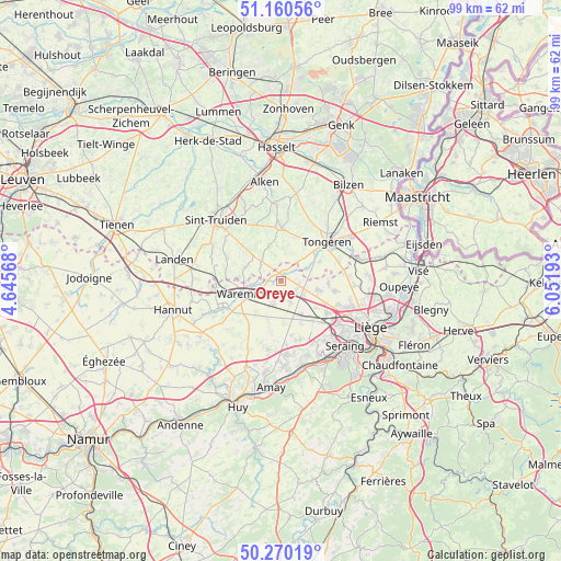
| Map corner | latitude | longitude |
|---|---|---|
| Upper-left | 51.16056°, | 4.64568° |
| Center: | 50.71749°, | 5.3488° |
| Lower-right: | 50.27019°, | 6.05193° |
| Map W x H: | 99×99 km | = 61.5×61.5mi |
| max Lat: | 51.46791° ⇑56.7% North |
| Oreye: | 50.71749° |
| min Lat: | ⇓43.3% South 49.53771° |
| min Long | Oreye | max Long |
| 2.59368° | 5.3488° | 6.25749° |
| W 79.2%⇐ | ⇒20.8% E |
Elevation
Elevation of Oreye is 112 m = 367 ft, and this is 12.5 m = 41 ft above average elevation for this country.
| Max E: |
582 m = 1909 ft | 32.3% |
| Oreye | 112 m 367 ft | |
| Avg. | 99.5 m = 326 ft | |
Min E: |
1 m = 3 ft | 67.7% |
See also: Belgium elevation on elevation.city.
Geographical zone
Oreye is located in North temperate zone (between Tropic of Cancer and the Arctic Circle). Distance of this North polar circle is 1761.9 km =1094.8 mi to North.| Distance of | km | miles | from Oreye |
|---|---|---|---|
| North Pole | 4367.8 | 2714 | to North |
| Arctic Circle | 1761.9 | 1094.8 | to North |
| Tropic Cancer | 3033.3 | 1884.8 | to South |
| Equator | 5639.3 | 3504.1 | to South |


Nearby cities:
15 places around Oreye: (largest is in red/bold)
• Ans
13.5 km =8.4 mi,  116°
116°
• Awans
9.8 km =6.1 mi, 124°
• Berloz
9.8 km =6.1 mi,  257°
257°
• Borgloon
9.7 km =6 mi,  357°
357°
• Crisnée
3.5 km =2.2 mi,  90°
90°
• Donceel
8 km =5 mi,  194°
194°
• Faimes
8.7 km =5.4 mi,  225°
225°
• Fexhe-le-Haut-Clocher
6.8 km =4.2 mi,  148°
148°
• Geer
13.4 km =8.3 mi,  246°
246°
• Heers
5.2 km =3.2 mi,  320°
320°
• Juprelle
12.9 km =8 mi, 94°
• Remicourt
4.3 km =2.7 mi,  199°
199°
• Tongeren
10.8 km =6.7 mi,  49°
49°
• Verlaine
12.4 km =7.7 mi, 190°
• Waremme
6.9 km =4.3 mi, 251°
Sources, notices
• [Note1] Compared only with cities in Belgium existing in our database
• [Src1] Map data: © OpenStreetMap contributors (CC-BY-SA)
• [Src2] Other city data from geonames.org with taken over terms of usage.
• [Src3] Geographical zone / Annual Mean Temperature by Robert A. Rohde @ Wikipedia
