Sint-Truiden geodata
Sint-Truiden (Flanders) is a populated place; located in Belgium in Europe/Brussels (GMT+2) time zone. With population of 37,859 people, there are 29 cities with bigger population in this country. Compared to other cities in Belgium, 51.4% of cities are located further ↓South; 72.7% of cities are located further ←West and 52% of cities have lower elevation than Sint-Truiden. Note1
Administrative division(s):
- Level 1: Flanders
- Level 2: Provincie Limburg
- Level 3: Arrondissement Hasselt
- Level 4: Sint-Truiden


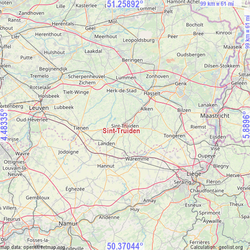
Sint-Truiden GPS coordinates[2]
50° 49' 0.444" North, 5° 11' 11.292" East
| Map corner | latitude | longitude |
|---|---|---|
| Upper-left | 51.25892°, | 4.48335° |
| Center: | 50.81679°, | 5.18647° |
| Lower-right: | 50.37044°, | 5.8896° |
| Map W x H: | 98.8×98.8 km | = 61.4×61.4mi |
| max Lat: | 51.46791° ⇑48.6% North |
| Sint-Truiden: | 50.81679° |
| min Lat: | ⇓51.4% South 49.53771° |
| min Long | Sint-Truiden | max Long |
| 2.59368° | 5.18647° | 6.25749° |
| W 72.7%⇐ | ⇒27.3% E |
Elevation
Elevation of Sint-Truiden is 54 m = 177 ft, and this is 45.5 m = 149 ft below average elevation for this country.
| Max E: |
582 m = 1909 ft | 48% |
| Avg. | 99.5 m = 326 ft | |
| Sint-Truiden | 54 m = 177 ft | |
Min E: |
1 m = 3 ft | 52% |
See also: Belgium elevation on elevation.city.
Geographical zone
Sint-Truiden is located in North temperate zone (between Tropic of Cancer and the Arctic Circle). Distance of this North polar circle is 1750.9 km =1088 mi to North.| Distance of | km | miles | from Sint-Truiden |
|---|---|---|---|
| North Pole | 4356.8 | 2707.2 | to North |
| Arctic Circle | 1750.9 | 1088 | to North |
| Tropic Cancer | 3044.4 | 1891.7 | to South |
| Equator | 5650.3 | 3510.9 | to South |


Nearby cities:
15 places around Sint-Truiden: (largest is in red/bold)
• Alken
10.6 km =6.6 mi,  52°
52°
• Berloz
13.3 km =8.3 mi,  172°
172°
• Borgloon
11.1 km =6.9 mi,  96°
96°
• Geetbets
10.1 km =6.3 mi,  328°
328°
• Gingelom
8.5 km =5.3 mi,  205°
205°
• Heers
10.7 km =6.6 mi,  130°
130°
• Herk-de-Stad
13.8 km =8.6 mi,  354°
354°
• Kortenaken
13.5 km =8.4 mi,  318°
318°
• Landen
10.2 km =6.3 mi,  225°
225°
• Nieuwerkerken
5.3 km =3.3 mi,  6°
6°
• Sint-Joris
8.5 km =5.3 mi,  44°
44°
• Terkoest
11 km =6.8 mi,  34°
34°
• Waremme
14.1 km =8.8 mi,  159°
159°
• Wellen
11 km =6.8 mi,  75°
75°
• Zoutleeuw
6.1 km =3.8 mi,  287°
287°
Sources, notices
• [Note1] Compared only with cities in Belgium existing in our database
• [Src1] Map data: © OpenStreetMap contributors (CC-BY-SA)
• [Src2] Other city data from geonames.org with taken over terms of usage.
• [Src3] Geographical zone / Annual Mean Temperature by Robert A. Rohde @ Wikipedia
