Titao geodata
Titao (Nord) is a seat of a second-order administrative division; located in Burkina Faso in Africa/Ouagadougou (GMT+0) time zone. With population of 19,131 people, there are 23 cities with bigger population in this country. Compared to other cities in Burkina Faso, 92.4% of cities are located further ↓South; 72.2% of cities are located further →East and 79.7% of cities have lower elevation than Titao. Note1


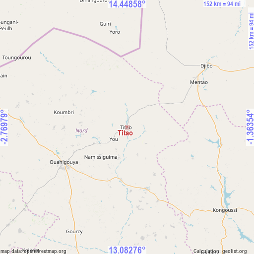
Titao GPS coordinates[2]
13° 46' 0.012" North, 2° 4' 0.012" West
| Map corner | latitude | longitude |
|---|---|---|
| Upper-left | 14.44858°, | -2.76979° |
| Center: | 13.76667°, | -2.06667° |
| Lower-right: | 13.08276°, | -1.36354° |
| Map W x H: | 151.9×151.9 km | = 94.4×94.4mi |
| max Lat: | 14.96549° ⇑7.6% North |
| Titao: | 13.76667° |
| min Lat: | ⇓92.4% South 9.88333° |
| min Long | Titao | max Long |
| -5.16667° | -2.06667° | 1.78838° |
| W 27.8%⇐ | ⇒72.2% E |
Elevation
Elevation of Titao is 326 m = 1070 ft, and this is 23 m = 75 ft above average elevation for this country.
| Max E: |
423 m = 1388 ft | 20.3% |
| Titao | 326 m 1070 ft | |
| Avg. | 303 m = 994 ft | |
Min E: |
222 m = 728 ft | 79.7% |
See also: Burkina Faso elevation on elevation.city.
Geographical zone
Titao is located in North Torrid zone (between Equator and Tropic of Cancer). Distance of this Northern Tropic circle is 1075.2 km =668.1 mi to North.| Distance of | km | miles | from Titao |
|---|---|---|---|
| North Pole | 8476.4 | 5267 | to North |
| Arctic Circle | 5870.5 | 3647.8 | to North |
| Tropic Cancer | 1075.2 | 668.1 | to North |
| Equator | 1530.7 | 951.1 | to South |


Nearby cities:
15 places around Titao: (largest is in red/bold)
• Boussé
124.3 km =77.2 mi,  171°
171°
• Dapélogo
134.4 km =83.5 mi,  154°
154°
• Djibo
60.3 km =37.5 mi,  52°
52°
• Gourcy
69.7 km =43.3 mi,  206°
206°
• Kaya
130.1 km =80.8 mi,  125°
125°
• Kongoussi
75.6 km =47 mi, 130°
• Mané
116.6 km =72.5 mi,  137°
137°
• Niou
111.8 km =69.5 mi, 172°
• Ouahigouya
43.5 km =27 mi,  241°
241°
• Ourgou-Manéga
125.3 km =77.9 mi, 151°
• Siglé
136 km =84.5 mi, 171°
• Tougan
133.1 km =82.7 mi,  234°
234°
• Toéghin
111.9 km =69.5 mi,  160°
160°
• Yako
92.2 km =57.3 mi,  193°
193°
• Zitenga
139.7 km =86.8 mi, 144°
Sources, notices
• [Note1] Compared only with cities in Burkina Faso existing in our database
• [Src1] Map data: © OpenStreetMap contributors (CC-BY-SA)
• [Src2] Other city data from geonames.org with taken over terms of usage.
• [Src3] Geographical zone / Annual Mean Temperature by Robert A. Rohde @ Wikipedia
