Djibo geodata
Djibo (Sahel) is a seat of a second-order administrative division; located in Burkina Faso in Africa/Ouagadougou (GMT+0) time zone. With population of 22,223 people, there are 22 cities with bigger population in this country. Compared to other cities in Burkina Faso, 94.9% of cities are located further ↓South; 51.9% of cities are located further →East and 55.7% of cities have higher elevation than Djibo. Note1


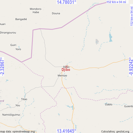
Djibo GPS coordinates[2]
14° 5' 57.84" North, 1° 37' 31.944" West
| Map corner | latitude | longitude |
|---|---|---|
| Upper-left | 14.78031°, | -2.32867° |
| Center: | 14.0994°, | -1.62554° |
| Lower-right: | 13.41645°, | -0.92242° |
| Map W x H: | 151.6×151.6 km | = 94.2×94.2mi |
| max Lat: | 14.96549° ⇑5.1% North |
| Djibo: | 14.0994° |
| min Lat: | ⇓94.9% South 9.88333° |
| min Long | Djibo | max Long |
| -5.16667° | -1.62554° | 1.78838° |
| W 48.1%⇐ | ⇒51.9% E |
Elevation
Elevation of Djibo is 301 m = 988 ft, and this is 2 m = 7 ft below average elevation for this country.
| Max E: |
423 m = 1388 ft | 55.7% |
| Avg. | 303 m = 994 ft | |
| Djibo | 301 m = 988 ft | |
Min E: |
222 m = 728 ft | 44.3% |
See also: Burkina Faso elevation on elevation.city.
Geographical zone
Djibo is located in North Torrid zone (between Equator and Tropic of Cancer). Distance of this Northern Tropic circle is 1038.2 km =645.1 mi to North.| Distance of | km | miles | from Djibo |
|---|---|---|---|
| North Pole | 8439.4 | 5244 | to North |
| Arctic Circle | 5833.5 | 3624.8 | to North |
| Tropic Cancer | 1038.2 | 645.1 | to North |
| Equator | 1567.7 | 974.1 | to South |


Nearby cities:
15 places around Djibo: (largest is in red/bold)
• Boussouma
144.7 km =89.9 mi,  156°
156°
• Déou
112.4 km =69.8 mi,  60°
60°
• Gourcy
126.9 km =78.9 mi,  218°
218°
• Kaya
126.4 km =78.5 mi,  152°
152°
• Kongoussi
86.6 km =53.8 mi,  173°
173°
• Korsimoro
154 km =95.7 mi, 156°
• Mané
127.2 km =79 mi, 166°
• Niou
151.6 km =94.2 mi,  192°
192°
• Ouahigouya
103.4 km =64.2 mi,  236°
236°
• Ourgou-Manéga
147.3 km =91.5 mi,  175°
175°
• Oursi
140.9 km =87.6 mi, 62°
• Titao
60.3 km =37.5 mi,  232°
232°
• Toéghin
143.1 km =88.9 mi, 184°
• Yako
144.2 km =89.6 mi,  208°
208°
• Zitenga
154 km =95.7 mi, 167°
Sources, notices
• [Note1] Compared only with cities in Burkina Faso existing in our database
• [Src1] Map data: © OpenStreetMap contributors (CC-BY-SA)
• [Src2] Other city data from geonames.org with taken over terms of usage.
• [Src3] Geographical zone / Annual Mean Temperature by Robert A. Rohde @ Wikipedia
