Gourcy geodata
Gourcy (Nord) is a seat of a second-order administrative division; located in Burkina Faso in Africa/Ouagadougou (GMT+0) time zone. With population of 16,765 people, there are 27 cities with bigger population in this country. Compared to other cities in Burkina Faso, 84.8% of cities are located further ↓South; 75.9% of cities are located further →East and 84.8% of cities have lower elevation than Gourcy. Note1


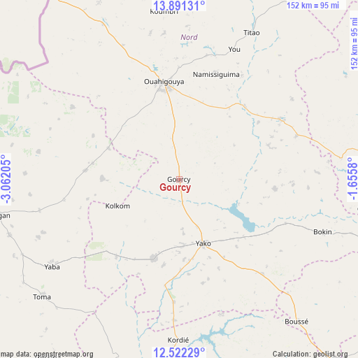
Gourcy GPS coordinates[2]
13° 12' 27.936" North, 2° 21' 32.148" West
| Map corner | latitude | longitude |
|---|---|---|
| Upper-left | 13.89131°, | -3.06205° |
| Center: | 13.20776°, | -2.35893° |
| Lower-right: | 12.52229°, | -1.6558° |
| Map W x H: | 152.2×152.2 km | = 94.6×94.6mi |
| max Lat: | 14.96549° ⇑15.2% North |
| Gourcy: | 13.20776° |
| min Lat: | ⇓84.8% South 9.88333° |
| min Long | Gourcy | max Long |
| -5.16667° | -2.35893° | 1.78838° |
| W 24.1%⇐ | ⇒75.9% E |
Elevation
Elevation of Gourcy is 331 m = 1086 ft, and this is 28 m = 92 ft above average elevation for this country.
| Max E: |
423 m = 1388 ft | 15.2% |
| Gourcy | 331 m 1086 ft | |
| Avg. | 303 m = 994 ft | |
Min E: |
222 m = 728 ft | 84.8% |
See also: Burkina Faso elevation on elevation.city.
Geographical zone
Gourcy is located in North Torrid zone (between Equator and Tropic of Cancer). Distance of this Northern Tropic circle is 1137.4 km =706.7 mi to North.| Distance of | km | miles | from Gourcy |
|---|---|---|---|
| North Pole | 8538.5 | 5305.6 | to North |
| Arctic Circle | 5932.6 | 3686.3 | to North |
| Tropic Cancer | 1137.4 | 706.7 | to North |
| Equator | 1468.6 | 912.5 | to South |


Nearby cities:
15 places around Gourcy: (largest is in red/bold)
• Boussé
78.9 km =49 mi,  140°
140°
• Gousi
77.5 km =48.2 mi,  217°
217°
• Kongoussi
90.2 km =56 mi,  81°
81°
• Laye
98.2 km =61 mi, 140°
• Niou
67 km =41.6 mi, 136°
• Ouahigouya
42.2 km =26.2 mi,  350°
350°
• Ourgou-Manéga
103.8 km =64.5 mi,  117°
117°
• Réo
99.5 km =61.8 mi,  187°
187°
• Siglé
88.6 km =55.1 mi, 144°
• Sièn
81.9 km =50.9 mi,  225°
225°
• Titao
69.7 km =43.3 mi,  26°
26°
• Toma
76.9 km =47.8 mi, 229°
• Tougan
78.4 km =48.7 mi,  258°
258°
• Toéghin
81.1 km =50.4 mi, 122°
• Yako
29.6 km =18.4 mi,  158°
158°
Sources, notices
• [Note1] Compared only with cities in Burkina Faso existing in our database
• [Src1] Map data: © OpenStreetMap contributors (CC-BY-SA)
• [Src2] Other city data from geonames.org with taken over terms of usage.
• [Src3] Geographical zone / Annual Mean Temperature by Robert A. Rohde @ Wikipedia
