Toma geodata
Toma (Boucle du Mouhoun) is a seat of a second-order administrative division; located in Burkina Faso in Africa/Ouagadougou (GMT+0) time zone. With population of 12,401 people, there are 33 cities with bigger population in this country. Compared to other cities in Burkina Faso, 69.6% of cities are located further ↓South; 83.5% of cities are located further →East and 73.4% of cities have higher elevation than Toma. Note1


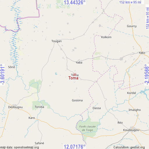
Toma GPS coordinates[2]
12° 45' 30.384" North, 2° 53' 55.644" West
| Map corner | latitude | longitude |
|---|---|---|
| Upper-left | 13.44326°, | -3.60191° |
| Center: | 12.75844°, | -2.89879° |
| Lower-right: | 12.07176°, | -2.19566° |
| Map W x H: | 152.5×152.5 km | = 94.8×94.8mi |
| max Lat: | 14.96549° ⇑30.4% North |
| Toma: | 12.75844° |
| min Lat: | ⇓69.6% South 9.88333° |
| min Long | Toma | max Long |
| -5.16667° | -2.89879° | 1.78838° |
| W 16.5%⇐ | ⇒83.5% E |
Elevation
Elevation of Toma is 287 m = 942 ft, and this is 16 m = 52 ft below average elevation for this country.
| Max E: |
423 m = 1388 ft | 73.4% |
| Avg. | 303 m = 994 ft | |
| Toma | 287 m = 942 ft | |
Min E: |
222 m = 728 ft | 26.6% |
See also: Burkina Faso elevation on elevation.city.
Geographical zone
Toma is located in North Torrid zone (between Equator and Tropic of Cancer). Distance of this Northern Tropic circle is 1187.3 km =737.8 mi to North.| Distance of | km | miles | from Toma |
|---|---|---|---|
| North Pole | 8588.5 | 5336.6 | to North |
| Arctic Circle | 5982.6 | 3717.4 | to North |
| Tropic Cancer | 1187.3 | 737.8 | to North |
| Equator | 1418.6 | 881.5 | to South |


Nearby cities:
15 places around Toma: (largest is in red/bold)
• Barani
116.7 km =72.5 mi,  293°
293°
• Boromo
112.7 km =70 mi,  181°
181°
• Boussé
109.4 km =68 mi,  95°
95°
• Dédougou
69.2 km =43 mi,  241°
241°
• Gourcy
76.9 km =47.8 mi,  49°
49°
• Gousi
16 km =9.9 mi,  135°
135°
• Koudougou
80.9 km =50.3 mi,  134°
134°
• Niou
104.7 km =65.1 mi,  89°
89°
• Nouna
104.6 km =65 mi,  268°
268°
• Ouahigouya
105.2 km =65.4 mi,  29°
29°
• Réo
67.4 km =41.9 mi, 136°
• Siglé
112 km =69.6 mi, 101°
• Sièn
7.3 km =4.5 mi, 179°
• Tougan
39.5 km =24.5 mi,  332°
332°
• Yako
72.7 km =45.2 mi,  72°
72°
Sources, notices
• [Note1] Compared only with cities in Burkina Faso existing in our database
• [Src1] Map data: © OpenStreetMap contributors (CC-BY-SA)
• [Src2] Other city data from geonames.org with taken over terms of usage.
• [Src3] Geographical zone / Annual Mean Temperature by Robert A. Rohde @ Wikipedia
