Tougan geodata
Tougan (Boucle du Mouhoun) is a seat of a second-order administrative division; located in Burkina Faso in Africa/Ouagadougou (GMT+0) time zone. With population of 17,590 people, there are 25 cities with bigger population in this country. Compared to other cities in Burkina Faso, 81% of cities are located further ↓South; 88.6% of cities are located further →East and 58.2% of cities have higher elevation than Tougan. Note1


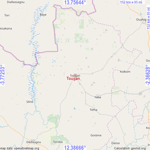
Tougan GPS coordinates[2]
13° 4' 21" North, 3° 4' 9.84" West
| Map corner | latitude | longitude |
|---|---|---|
| Upper-left | 13.75644°, | -3.77253° |
| Center: | 13.0725°, | -3.0694° |
| Lower-right: | 12.38666°, | -2.36628° |
| Map W x H: | 152.3×152.3 km | = 94.6×94.6mi |
| max Lat: | 14.96549° ⇑19% North |
| Tougan: | 13.0725° |
| min Lat: | ⇓81% South 9.88333° |
| min Long | Tougan | max Long |
| -5.16667° | -3.0694° | 1.78838° |
| W 11.4%⇐ | ⇒88.6% E |
Elevation
Elevation of Tougan is 300 m = 984 ft, and this is 3 m = 10 ft below average elevation for this country.
| Max E: |
423 m = 1388 ft | 58.2% |
| Avg. | 303 m = 994 ft | |
| Tougan | 300 m = 984 ft | |
Min E: |
222 m = 728 ft | 41.8% |
See also: Burkina Faso elevation on elevation.city.
Geographical zone
Tougan is located in North Torrid zone (between Equator and Tropic of Cancer). Distance of this Northern Tropic circle is 1152.4 km =716.1 mi to North.| Distance of | km | miles | from Tougan |
|---|---|---|---|
| North Pole | 8553.5 | 5314.9 | to North |
| Arctic Circle | 5947.6 | 3695.7 | to North |
| Tropic Cancer | 1152.4 | 716.1 | to North |
| Equator | 1453.5 | 903.2 | to South |


Nearby cities:
15 places around Tougan: (largest is in red/bold)
• Barani
89.5 km =55.6 mi,  276°
276°
• Boussé
135.3 km =84.1 mi,  109°
109°
• Dédougou
79.9 km =49.6 mi,  212°
212°
• Gourcy
78.4 km =48.7 mi,  78°
78°
• Gousi
55 km =34.2 mi,  147°
147°
• Koudougou
119.1 km =74 mi,  139°
139°
• Niou
127.6 km =79.3 mi, 105°
• Nouna
94.1 km =58.5 mi,  246°
246°
• Ouahigouya
90.2 km =56 mi,  51°
51°
• Réo
105.9 km =65.8 mi, 142°
• Siglé
140.4 km =87.2 mi, 114°
• Sièn
46.1 km =28.6 mi,  156°
156°
• Titao
133.1 km =82.7 mi, 54°
• Toma
39.5 km =24.5 mi, 152°
• Yako
88.5 km =55 mi,  98°
98°
Sources, notices
• [Note1] Compared only with cities in Burkina Faso existing in our database
• [Src1] Map data: © OpenStreetMap contributors (CC-BY-SA)
• [Src2] Other city data from geonames.org with taken over terms of usage.
• [Src3] Geographical zone / Annual Mean Temperature by Robert A. Rohde @ Wikipedia
