Ouahigouya geodata
Ouahigouya (Nord) is a seat of a first-order administrative division; located in Burkina Faso in Africa/Ouagadougou (GMT+0) time zone. With population of 61,096 people, there are 3 cities with bigger population in this country. Compared to other cities in Burkina Faso, 91.1% of cities are located further ↓South; 78.5% of cities are located further →East and 82.3% of cities have lower elevation than Ouahigouya. Note1


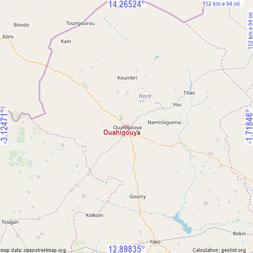
Ouahigouya GPS coordinates[2]
13° 34' 58.008" North, 2° 25' 17.688" West
| Map corner | latitude | longitude |
|---|---|---|
| Upper-left | 14.26524°, | -3.12471° |
| Center: | 13.58278°, | -2.42158° |
| Lower-right: | 12.89835°, | -1.71846° |
| Map W x H: | 152×152 km | = 94.4×94.4mi |
| max Lat: | 14.96549° ⇑8.9% North |
| Ouahigouya: | 13.58278° |
| min Lat: | ⇓91.1% South 9.88333° |
| min Long | Ouahigouya | max Long |
| -5.16667° | -2.42158° | 1.78838° |
| W 21.5%⇐ | ⇒78.5% E |
Elevation
Elevation of Ouahigouya is 328 m = 1076 ft, and this is 25 m = 82 ft above average elevation for this country.
| Max E: |
423 m = 1388 ft | 17.7% |
| Ouahigouya | 328 m 1076 ft | |
| Avg. | 303 m = 994 ft | |
Min E: |
222 m = 728 ft | 82.3% |
See also: Ouahigouya elevation on elevation.city.
Geographical zone
Ouahigouya is located in North Torrid zone (between Equator and Tropic of Cancer). Distance of this Northern Tropic circle is 1095.7 km =680.8 mi to North.| Distance of | km | miles | from Ouahigouya |
|---|---|---|---|
| North Pole | 8496.8 | 5279.7 | to North |
| Arctic Circle | 5890.9 | 3660.4 | to North |
| Tropic Cancer | 1095.7 | 680.8 | to North |
| Equator | 1510.3 | 938.5 | to South |


Nearby cities:
15 places around Ouahigouya: (largest is in red/bold)
• Boussé
117.3 km =72.9 mi,  150°
150°
• Djibo
103.4 km =64.2 mi,  56°
56°
• Gourcy
42.2 km =26.2 mi,  170°
170°
• Gousi
110.7 km =68.8 mi,  201°
201°
• Kongoussi
100.1 km =62.2 mi,  106°
106°
• Mané
134 km =83.3 mi,  119°
119°
• Niou
104.7 km =65.1 mi, 149°
• Ourgou-Manéga
133.3 km =82.8 mi,  132°
132°
• Siglé
128 km =79.5 mi, 153°
• Sièn
111.6 km =69.3 mi,  207°
207°
• Titao
43.5 km =27 mi, 61°
• Toma
105.2 km =65.4 mi, 209°
• Tougan
90.2 km =56 mi,  231°
231°
• Toéghin
113.6 km =70.6 mi,  138°
138°
• Yako
71.5 km =44.4 mi, 165°
Sources, notices
• [Note1] Compared only with cities in Burkina Faso existing in our database
• [Src1] Map data: © OpenStreetMap contributors (CC-BY-SA)
• [Src2] Other city data from geonames.org with taken over terms of usage.
• [Src3] Geographical zone / Annual Mean Temperature by Robert A. Rohde @ Wikipedia
