Natitingou geodata
Natitingou (Atakora) is a seat of a first-order administrative division; located in Benin in Africa/Porto-Novo (GMT+1) time zone. With population of 80,892 people, there are 10 cities with bigger population in this country. Compared to other cities in Benin, 84.8% of cities are located further ↓South; 97.8% of cities are located further →East and 97.8% of cities have lower elevation than Natitingou. Note1


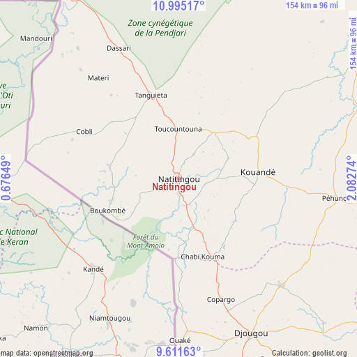
Natitingou GPS coordinates[2]
10° 18' 14.976" North, 1° 22' 46.632" East
| Map corner | latitude | longitude |
|---|---|---|
| Upper-left | 10.99517°, | 0.67649° |
| Center: | 10.30416°, | 1.37962° |
| Lower-right: | 9.61163°, | 2.08274° |
| Map W x H: | 153.8×153.8 km | = 95.6×95.6mi |
| max Lat: | 11.86819° ⇑15.2% North |
| Natitingou: | 10.30416° |
| min Lat: | ⇓84.8% South 6.28036° |
| min Long | Natitingou | max Long |
| 1.26651° | 1.37962° | 3.38327° |
| W 2.2%⇐ | ⇒97.8% E |
Elevation
Elevation of Natitingou is 450 m = 1476 ft, and this is 287.2 m = 942 ft above average elevation for this country.
| Max E: |
472 m = 1549 ft | 2.2% |
| Natitingou | 450 m 1476 ft | |
| Avg. | 162.8 m = 534 ft | |
Min E: |
1 m = 3 ft | 97.8% |
See also: Natitingou elevation on elevation.city.
Geographical zone
Natitingou is located in North Torrid zone (between Equator and Tropic of Cancer). Distance of Equator is 1145.7 km =711.9 mi to South.| Distance of | km | miles | from Natitingou |
|---|---|---|---|
| North Pole | 8861.3 | 5506.2 | to North |
| Arctic Circle | 6255.5 | 3887 | to North |
| Tropic Cancer | 1460.2 | 907.3 | to North |
| Equator | 1145.7 | 711.9 | to South |


Nearby cities:
15 places around Natitingou: (largest is in red/bold)
• Angara-Débou
215.7 km =134 mi,  58°
58°
• Banikoara
160 km =99.4 mi,  46°
46°
• Bassila
147.5 km =91.7 mi,  167°
167°
• Bembèrèkè
140.7 km =87.4 mi,  93°
93°
• Bétérou
156.1 km =97 mi,  141°
141°
• Djougou
73.3 km =45.5 mi,  154°
154°
• Goumori
139.5 km =86.7 mi, 45°
• Guilmaro
47.6 km =29.6 mi, 52°
• Kandi
193.7 km =120.4 mi, 61°
• Malanville
279.4 km =173.6 mi, 51°
• Nikki
204.5 km =127.1 mi,  101°
101°
• Parakou
174.2 km =108.2 mi,  128°
128°
• Savalou
272.2 km =169.1 mi, 166°
• Tanguiéta
37.4 km =23.2 mi,  340°
340°
• Tchaourou
206.6 km =128.4 mi, 139°
Sources, notices
• [Note1] Compared only with cities in Benin existing in our database
• [Src1] Map data: © OpenStreetMap contributors (CC-BY-SA)
• [Src2] Other city data from geonames.org with taken over terms of usage.
• [Src3] Geographical zone / Annual Mean Temperature by Robert A. Rohde @ Wikipedia
