Tanguiéta geodata
Tanguiéta (Atakora) is a populated place; located in Benin in Africa/Porto-Novo (GMT+1) time zone. With population of 19,833 people, there are 28 cities with bigger population in this country. Compared to other cities in Benin, 89.1% of cities are located further ↓South; 100% of cities are located further →East and 71.7% of cities have lower elevation than Tanguiéta. Note1


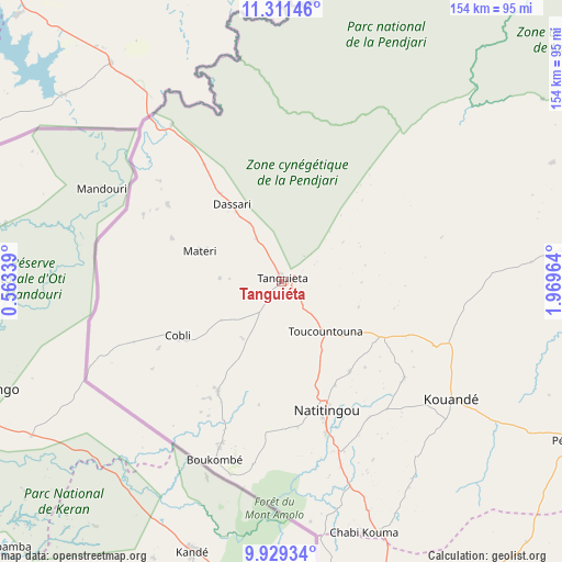
Tanguiéta GPS coordinates[2]
10° 37' 16.248" North, 1° 15' 59.436" East
| Map corner | latitude | longitude |
|---|---|---|
| Upper-left | 11.31146°, | 0.56339° |
| Center: | 10.62118°, | 1.26651° |
| Lower-right: | 9.92934°, | 1.96964° |
| Map W x H: | 153.7×153.7 km | = 95.5×95.5mi |
| max Lat: | 11.86819° ⇑10.9% North |
| Tanguiéta: | 10.62118° |
| min Lat: | ⇓89.1% South 6.28036° |
| min Long | Tanguiéta | max Long |
| 1.26651° | 1.26651° | 3.38327° |
| W 0%⇐ | ⇒100% E |
Elevation
Elevation of Tanguiéta is 242 m = 794 ft, and this is 79.2 m = 260 ft above average elevation for this country.
| Max E: |
472 m = 1549 ft | 28.3% |
| Tanguiéta | 242 m 794 ft | |
| Avg. | 162.8 m = 534 ft | |
Min E: |
1 m = 3 ft | 71.7% |
See also: Benin elevation on elevation.city.
Geographical zone
Tanguiéta is located in North Torrid zone (between Equator and Tropic of Cancer). Distance of Equator is 1181 km =733.8 mi to South.| Distance of | km | miles | from Tanguiéta |
|---|---|---|---|
| North Pole | 8826.1 | 5484.3 | to North |
| Arctic Circle | 6220.2 | 3865.1 | to North |
| Tropic Cancer | 1425 | 885.5 | to North |
| Equator | 1181 | 733.8 | to South |


Nearby cities:
15 places around Tanguiéta: (largest is in red/bold)
• Angara-Débou
210.7 km =130.9 mi,  68°
68°
• Banikoara
148.5 km =92.3 mi,  59°
59°
• Bassila
184.6 km =114.7 mi,  166°
166°
• Bembèrèkè
158.9 km =98.7 mi,  105°
105°
• Bétérou
191.8 km =119.2 mi,  145°
145°
• Djougou
110.5 km =68.7 mi,  156°
156°
• Goumori
128.2 km =79.7 mi, 60°
• Guilmaro
50.4 km =31.3 mi,  97°
97°
• Kandi
191.3 km =118.9 mi, 72°
• Malanville
269.3 km =167.3 mi, 59°
• Natitingou
37.4 km =23.2 mi, 160°
• Nikki
225.8 km =140.3 mi, 109°
• Parakou
206.6 km =128.4 mi,  133°
133°
• Savalou
309.4 km =192.3 mi, 165°
• Tchaourou
241.8 km =150.2 mi,  142°
142°
Sources, notices
• [Note1] Compared only with cities in Benin existing in our database
• [Src1] Map data: © OpenStreetMap contributors (CC-BY-SA)
• [Src2] Other city data from geonames.org with taken over terms of usage.
• [Src3] Geographical zone / Annual Mean Temperature by Robert A. Rohde @ Wikipedia
