Guilmaro geodata
Guilmaro (Atakora) is a populated place; located in Benin in Africa/Porto-Novo (GMT+1) time zone. With population of 6,516 people, there are 32 cities with bigger population in this country. Compared to other cities in Benin, 87% of cities are located further ↓South; 87% of cities are located further →East and 100% of cities have lower elevation than Guilmaro. Note1


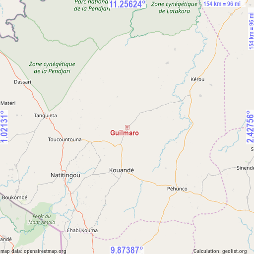
Guilmaro GPS coordinates[2]
10° 33' 56.988" North, 1° 43' 27.984" East
| Map corner | latitude | longitude |
|---|---|---|
| Upper-left | 11.25624°, | 1.02131° |
| Center: | 10.56583°, | 1.72444° |
| Lower-right: | 9.87387°, | 2.42756° |
| Map W x H: | 153.7×153.7 km | = 95.5×95.5mi |
| max Lat: | 11.86819° ⇑13% North |
| Guilmaro: | 10.56583° |
| min Lat: | ⇓87% South 6.28036° |
| min Long | Guilmaro | max Long |
| 1.26651° | 1.72444° | 3.38327° |
| W 13%⇐ | ⇒87% E |
Elevation
Elevation of Guilmaro is 472 m = 1549 ft, and this is 309.2 m = 1014 ft above average elevation for this country.
| Max E: |
472 m = 1549 ft | 0% |
| Guilmaro | 472 m 1549 ft | |
| Avg. | 162.8 m = 534 ft | |
Min E: |
1 m = 3 ft | 100% |
See also: Benin elevation on elevation.city.
Geographical zone
Guilmaro is located in North Torrid zone (between Equator and Tropic of Cancer). Distance of Equator is 1174.8 km =730 mi to South.| Distance of | km | miles | from Guilmaro |
|---|---|---|---|
| North Pole | 8832.3 | 5488.1 | to North |
| Arctic Circle | 6226.4 | 3868.9 | to North |
| Tropic Cancer | 1431.1 | 889.2 | to North |
| Equator | 1174.8 | 730 | to South |


Nearby cities:
15 places around Guilmaro: (largest is in red/bold)
• Angara-Débou
168.3 km =104.6 mi,  59°
59°
• Banikoara
112.8 km =70.1 mi,  43°
43°
• Bassila
173.3 km =107.7 mi,  182°
182°
• Bembèrèkè
109.3 km =67.9 mi,  110°
110°
• Bétérou
162.8 km =101.2 mi,  158°
158°
• Djougou
95.5 km =59.3 mi, 183°
• Goumori
92.4 km =57.4 mi, 42°
• Kandi
146.9 km =91.3 mi, 64°
• Malanville
231.7 km =144 mi,  51°
51°
• Natitingou
47.6 km =29.6 mi,  232°
232°
• Nikki
176.9 km =109.9 mi, 113°
• Parakou
168.8 km =104.9 mi,  144°
144°
• Savé
293.6 km =182.4 mi, 163°
• Tanguiéta
50.4 km =31.3 mi,  277°
277°
• Tchaourou
209.8 km =130.4 mi,  152°
152°
Sources, notices
• [Note1] Compared only with cities in Benin existing in our database
• [Src1] Map data: © OpenStreetMap contributors (CC-BY-SA)
• [Src2] Other city data from geonames.org with taken over terms of usage.
• [Src3] Geographical zone / Annual Mean Temperature by Robert A. Rohde @ Wikipedia
