Oruro geodata
Oruro is a seat of a first-order administrative division; located in Bolivia in America/La_Paz (GMT-4) time zone. With population of 208,684 people, there are 4 cities with bigger population in this country. Compared to other cities in Bolivia, 52.8% of cities are located further ↑North; 82% of cities are located further →East and 94.4% of cities have lower elevation than Oruro. Note1


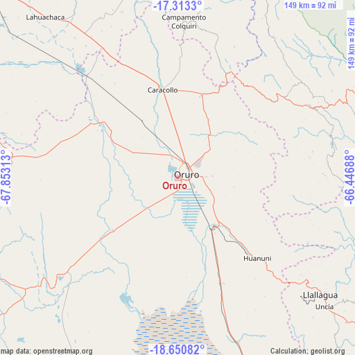
Oruro GPS coordinates[2]
17° 58' 59.988" South, 67° 9' 0" West
| Map corner | latitude | longitude |
|---|---|---|
| Upper-left | -17.3133°, | -67.85313° |
| Center: | -17.98333°, | -67.15° |
| Lower-right: | -18.65082°, | -66.44688° |
| Map W x H: | 148.7×148.7 km | = 92.4×92.4mi |
| max Lat: | -9.71828° ⇑52.8% North |
| Oruro: | -17.98333° |
| min Lat: | ⇓47.2% South -22.73206° |
| min Long | Oruro | max Long |
| -69.14843° | -67.15° | -57.76667° |
| W 18%⇐ | ⇒82% E |
Elevation
Elevation of Oruro is 3936 m = 12913 ft, and this is 1924.7 m = 6315 ft above average elevation for this country.
| Max E: |
4732 m = 15525 ft | 5.6% |
| Oruro | 3936 m 12913 ft | |
| Avg. | 2011.3 m = 6599 ft | |
Min E: |
92 m = 302 ft | 94.4% |
See also: Oruro elevation on elevation.city.
Geographical zone
Oruro is located in South Torrid zone (between Equator and Tropic of Capricorn). Distance of this Southern Tropic circle is 606.4 km =376.8 mi to South.| Distance of | km | miles | from Oruro |
|---|---|---|---|
| Equator | 1999.6 | 1242.5 | to North |
| Tropic Capricorn | 606.4 | 376.8 | to South |
| Antarctic Circle | 5401.6 | 3356.4 | to South |
| South Pole | 8007.5 | 4975.6 | to South |


Nearby cities:
15 places around Oruro: (largest is in red/bold)
• Andamarca
96.2 km =59.8 mi,  203°
203°
• Belen
80.6 km =50.1 mi,  328°
328°
• Capinota
98.9 km =61.5 mi,  72°
72°
• Colchani
87.2 km =54.2 mi,  31°
31°
• Colquiri
66.1 km =41.1 mi,  2°
2°
• Eucaliptus
59 km =36.7 mi,  318°
318°
• Huanuni
47.5 km =29.5 mi,  135°
135°
• Independencia
106 km =65.9 mi,  19°
19°
• Irpa Irpa
98.1 km =61 mi, 72°
• Lahuachaca
88 km =54.7 mi, 320°
• Llallagua
77.3 km =48 mi,  129°
129°
• Machacamarca
25.1 km =15.6 mi,  147°
147°
• Poopó
48.2 km =30 mi,  156°
156°
• Sipe Sipe
100.6 km =62.5 mi,  53°
53°
• Totoral
64 km =39.8 mi, 152°
Sources, notices
• [Note1] Compared only with cities in Bolivia existing in our database
• [Src1] Map data: © OpenStreetMap contributors (CC-BY-SA)
• [Src2] Other city data from geonames.org with taken over terms of usage.
• [Src3] Geographical zone / Annual Mean Temperature by Robert A. Rohde @ Wikipedia
