Llallagua geodata
Llallagua (Potosí) is a populated place; located in Bolivia in America/La_Paz (GMT-4) time zone. With population of 28,069 people, there are 18 cities with bigger population in this country. Compared to other cities in Bolivia, 60.2% of cities are located further ↑North; 73.3% of cities are located further →East and 92.5% of cities have lower elevation than Llallagua. Note1


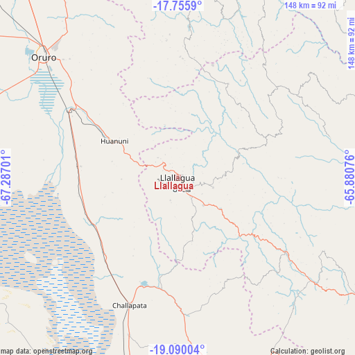
Llallagua GPS coordinates[2]
18° 25' 27.336" South, 66° 35' 1.968" West
| Map corner | latitude | longitude |
|---|---|---|
| Upper-left | -17.7559°, | -67.28701° |
| Center: | -18.42426°, | -66.58388° |
| Lower-right: | -19.09004°, | -65.88076° |
| Map W x H: | 148.3×148.3 km | = 92.1×92.1mi |
| max Lat: | -9.71828° ⇑60.2% North |
| Llallagua: | -18.42426° |
| min Lat: | ⇓39.8% South -22.73206° |
| min Long | Llallagua | max Long |
| -69.14843° | -66.58388° | -57.76667° |
| W 26.7%⇐ | ⇒73.3% E |
Elevation
Elevation of Llallagua is 3897 m = 12785 ft, and this is 1885.7 m = 6187 ft above average elevation for this country.
| Max E: |
4732 m = 15525 ft | 7.5% |
| Llallagua | 3897 m 12785 ft | |
| Avg. | 2011.3 m = 6599 ft | |
Min E: |
92 m = 302 ft | 92.5% |
See also: Bolivia elevation on elevation.city.
Geographical zone
Llallagua is located in South Torrid zone (between Equator and Tropic of Capricorn). Distance of this Southern Tropic circle is 557.3 km =346.3 mi to South.| Distance of | km | miles | from Llallagua |
|---|---|---|---|
| Equator | 2048.6 | 1272.9 | to North |
| Tropic Capricorn | 557.3 | 346.3 | to South |
| Antarctic Circle | 5352.6 | 3326 | to South |
| South Pole | 7958.5 | 4945.2 | to South |


Nearby cities:
15 places around Llallagua: (largest is in red/bold)
• Andamarca
105 km =65.2 mi,  247°
247°
• Capinota
86.3 km =53.6 mi,  23°
23°
• Challapata
56.6 km =35.2 mi,  200°
200°
• Cliza
115.7 km =71.9 mi,  36°
36°
• Cochabamba
123.6 km =76.8 mi, 21°
• Colquechaca
68.4 km =42.5 mi,  116°
116°
• Huanuni
30.5 km =19 mi,  299°
299°
• Irpa Irpa
85.5 km =53.1 mi, 23°
• Machacamarca
54 km =33.6 mi, 301°
• Oruro
77.3 km =48 mi,  309°
309°
• Poopó
40.7 km =25.3 mi,  276°
276°
• Quillacollo
119.2 km =74.1 mi, 15°
• Sipe Sipe
110.4 km =68.6 mi,  11°
11°
• Tarata
108.4 km =67.4 mi,  33°
33°
• Totoral
31.6 km =19.6 mi,  255°
255°
Sources, notices
• [Note1] Compared only with cities in Bolivia existing in our database
• [Src1] Map data: © OpenStreetMap contributors (CC-BY-SA)
• [Src2] Other city data from geonames.org with taken over terms of usage.
• [Src3] Geographical zone / Annual Mean Temperature by Robert A. Rohde @ Wikipedia
