Eucaliptus geodata
Eucaliptus (La Paz) is a populated place; located in Bolivia in America/La_Paz (GMT-4) time zone. With population of 2,373 people, there are 99 cities with bigger population in this country. Compared to other cities in Bolivia, 61.5% of cities are located further ↓South; 84.5% of cities are located further →East and 83.9% of cities have lower elevation than Eucaliptus. Note1


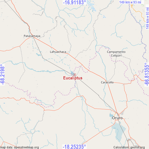
Eucaliptus GPS coordinates[2]
17° 34' 59.988" South, 67° 31' 0.012" West
| Map corner | latitude | longitude |
|---|---|---|
| Upper-left | -16.91183°, | -68.2198° |
| Center: | -17.58333°, | -67.51667° |
| Lower-right: | -18.25235°, | -66.81355° |
| Map W x H: | 149.1×149.1 km | = 92.6×92.6mi |
| max Lat: | -9.71828° ⇑38.5% North |
| Eucaliptus: | -17.58333° |
| min Lat: | ⇓61.5% South -22.73206° |
| min Long | Eucaliptus | max Long |
| -69.14843° | -67.51667° | -57.76667° |
| W 15.5%⇐ | ⇒84.5% E |
Elevation
Elevation of Eucaliptus is 3734 m = 12251 ft, and this is 1722.7 m = 5652 ft above average elevation for this country.
| Max E: |
4732 m = 15525 ft | 16.1% |
| Eucaliptus | 3734 m 12251 ft | |
| Avg. | 2011.3 m = 6599 ft | |
Min E: |
92 m = 302 ft | 83.9% |
See also: Bolivia elevation on elevation.city.
Geographical zone
Eucaliptus is located in South Torrid zone (between Equator and Tropic of Capricorn). Distance of this Southern Tropic circle is 650.8 km =404.4 mi to South.| Distance of | km | miles | from Eucaliptus |
|---|---|---|---|
| Equator | 1955.1 | 1214.8 | to North |
| Tropic Capricorn | 650.8 | 404.4 | to South |
| Antarctic Circle | 5446.1 | 3384 | to South |
| South Pole | 8052 | 5003.3 | to South |


Nearby cities:
15 places around Eucaliptus: (largest is in red/bold)
• Belen
24.3 km =15.1 mi,  351°
351°
• Colchani
89.9 km =55.9 mi,  70°
70°
• Colquiri
46.7 km =29 mi,  62°
62°
• Curahuara de Carangas
102.1 km =63.4 mi,  252°
252°
• Huanuni
106.5 km =66.2 mi,  137°
137°
• Independencia
92.6 km =57.5 mi,  53°
53°
• Lahuachaca
29 km =18 mi,  324°
324°
• Machacamarca
83.9 km =52.1 mi, 141°
• Oruro
59 km =36.7 mi, 138°
• Patacamaya
57.8 km =35.9 mi,  311°
311°
• Poopó
106 km =65.9 mi,  146°
146°
• Quime
73.9 km =45.9 mi,  25°
25°
• Sipe Sipe
121.1 km =75.2 mi,  82°
82°
• Totoral
122.1 km =75.9 mi, 146°
• Viloco
70.5 km =43.8 mi,  357°
357°
Sources, notices
• [Note1] Compared only with cities in Bolivia existing in our database
• [Src1] Map data: © OpenStreetMap contributors (CC-BY-SA)
• [Src2] Other city data from geonames.org with taken over terms of usage.
• [Src3] Geographical zone / Annual Mean Temperature by Robert A. Rohde @ Wikipedia
