Huanuni geodata
Huanuni (Oruro) is a populated place; located in Bolivia in America/La_Paz (GMT-4) time zone. With population of 15,492 people, there are 31 cities with bigger population in this country. Compared to other cities in Bolivia, 58.4% of cities are located further ↑North; 77% of cities are located further →East and 96.3% of cities have lower elevation than Huanuni. Note1


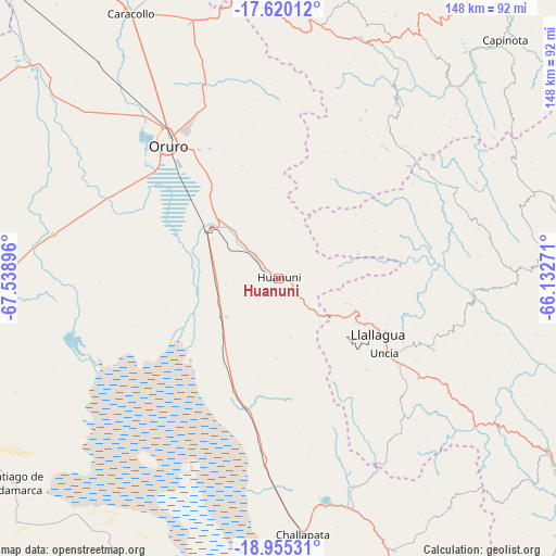
Huanuni GPS coordinates[2]
18° 17' 20.4" South, 66° 50' 8.988" West
| Map corner | latitude | longitude |
|---|---|---|
| Upper-left | -17.62012°, | -67.53896° |
| Center: | -18.289°, | -66.83583° |
| Lower-right: | -18.95531°, | -66.13271° |
| Map W x H: | 148.5×148.5 km | = 92.3×92.3mi |
| max Lat: | -9.71828° ⇑58.4% North |
| Huanuni: | -18.289° |
| min Lat: | ⇓41.6% South -22.73206° |
| min Long | Huanuni | max Long |
| -69.14843° | -66.83583° | -57.76667° |
| W 23%⇐ | ⇒77% E |
Elevation
Elevation of Huanuni is 3963 m = 13002 ft, and this is 1951.7 m = 6403 ft above average elevation for this country.
| Max E: |
4732 m = 15525 ft | 3.7% |
| Huanuni | 3963 m 13002 ft | |
| Avg. | 2011.3 m = 6599 ft | |
Min E: |
92 m = 302 ft | 96.3% |
See also: Bolivia elevation on elevation.city.
Geographical zone
Huanuni is located in South Torrid zone (between Equator and Tropic of Capricorn). Distance of this Southern Tropic circle is 572.4 km =355.7 mi to South.| Distance of | km | miles | from Huanuni |
|---|---|---|---|
| Equator | 2033.5 | 1263.6 | to North |
| Tropic Capricorn | 572.4 | 355.7 | to South |
| Antarctic Circle | 5367.6 | 3335.3 | to South |
| South Pole | 7973.5 | 4954.5 | to South |


Nearby cities:
15 places around Huanuni: (largest is in red/bold)
• Andamarca
89.4 km =55.6 mi,  232°
232°
• Capinota
88.5 km =55 mi,  43°
43°
• Challapata
68.5 km =42.6 mi,  174°
174°
• Colchani
108.8 km =67.6 mi,  6°
6°
• Colquechaca
98.9 km =61.5 mi,  117°
117°
• Colquiri
104.7 km =65.1 mi,  342°
342°
• Eucaliptus
106.5 km =66.2 mi,  317°
317°
• Irpa Irpa
87.6 km =54.4 mi, 43°
• Llallagua
30.5 km =19 mi, 119°
• Machacamarca
23.5 km =14.6 mi,  303°
303°
• Oruro
47.5 km =29.5 mi, 315°
• Poopó
17.2 km =10.7 mi, 233°
• Sipe Sipe
104.9 km =65.2 mi,  27°
27°
• Tarata
114.6 km =71.2 mi,  48°
48°
• Totoral
23.3 km =14.5 mi,  189°
189°
Sources, notices
• [Note1] Compared only with cities in Bolivia existing in our database
• [Src1] Map data: © OpenStreetMap contributors (CC-BY-SA)
• [Src2] Other city data from geonames.org with taken over terms of usage.
• [Src3] Geographical zone / Annual Mean Temperature by Robert A. Rohde @ Wikipedia
