Challapata geodata
Challapata (Oruro) is a populated place; located in Bolivia in America/La_Paz (GMT-4) time zone. With population of 8,016 people, there are 50 cities with bigger population in this country. Compared to other cities in Bolivia, 67.7% of cities are located further ↑North; 75.2% of cities are located further →East and 83.2% of cities have lower elevation than Challapata. Note1


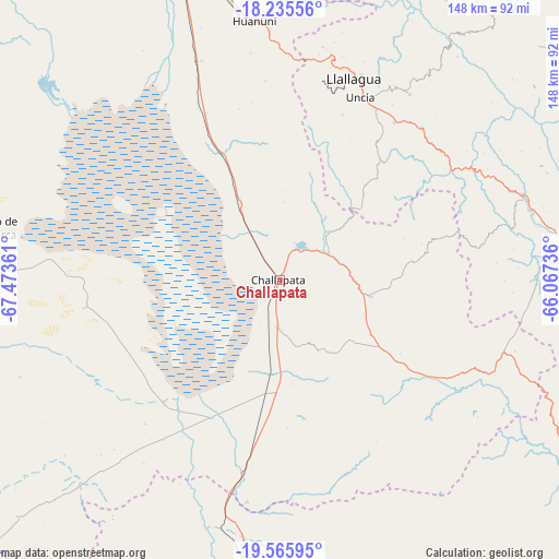
Challapata GPS coordinates[2]
18° 54' 7.488" South, 66° 46' 13.728" West
| Map corner | latitude | longitude |
|---|---|---|
| Upper-left | -18.23556°, | -67.47361° |
| Center: | -18.90208°, | -66.77048° |
| Lower-right: | -19.56595°, | -66.06736° |
| Map W x H: | 147.9×147.9 km | = 91.9×91.9mi |
| max Lat: | -9.71828° ⇑67.7% North |
| Challapata: | -18.90208° |
| min Lat: | ⇓32.3% South -22.73206° |
| min Long | Challapata | max Long |
| -69.14843° | -66.77048° | -57.76667° |
| W 24.8%⇐ | ⇒75.2% E |
Elevation
Elevation of Challapata is 3732 m = 12244 ft, and this is 1720.7 m = 5645 ft above average elevation for this country.
| Max E: |
4732 m = 15525 ft | 16.8% |
| Challapata | 3732 m 12244 ft | |
| Avg. | 2011.3 m = 6599 ft | |
Min E: |
92 m = 302 ft | 83.2% |
See also: Bolivia elevation on elevation.city.
Geographical zone
Challapata is located in South Torrid zone (between Equator and Tropic of Capricorn). Distance of this Southern Tropic circle is 504.2 km =313.3 mi to South.| Distance of | km | miles | from Challapata |
|---|---|---|---|
| Equator | 2101.7 | 1305.9 | to North |
| Tropic Capricorn | 504.2 | 313.3 | to South |
| Antarctic Circle | 5299.5 | 3293 | to South |
| South Pole | 7905.3 | 4912.1 | to South |


Nearby cities:
15 places around Challapata: (largest is in red/bold)
• Andamarca
78.8 km =49 mi,  279°
279°
• Capinota
142.9 km =88.8 mi,  22°
22°
• Chaunaca
137.7 km =85.6 mi,  95°
95°
• Colquechaca
83.7 km =52 mi,  74°
74°
• Huanuni
68.5 km =42.6 mi,  354°
354°
• Irpa Irpa
142.1 km =88.3 mi, 21°
• Llallagua
56.6 km =35.2 mi, 20°
• Machacamarca
85.3 km =53 mi,  341°
341°
• Maragua
142 km =88.2 mi, 96°
• Oruro
109.7 km =68.2 mi, 338°
• Piocera
145.2 km =90.2 mi,  83°
83°
• Poopó
61.6 km =38.3 mi, 340°
• Potolo
131.1 km =81.5 mi, 95°
• Potosí
131 km =81.4 mi,  125°
125°
• Totoral
46.5 km =28.9 mi, 346°
Sources, notices
• [Note1] Compared only with cities in Bolivia existing in our database
• [Src1] Map data: © OpenStreetMap contributors (CC-BY-SA)
• [Src2] Other city data from geonames.org with taken over terms of usage.
• [Src3] Geographical zone / Annual Mean Temperature by Robert A. Rohde @ Wikipedia
