Charagua geodata
Charagua (Santa Cruz) is a populated place; located in Bolivia in America/La_Paz (GMT-4) time zone. With population of 3,025 people, there are 84 cities with bigger population in this country. Compared to other cities in Bolivia, 80.1% of cities are located further ↑North; 86.3% of cities are located further ←West and 66.5% of cities have higher elevation than Charagua. Note1


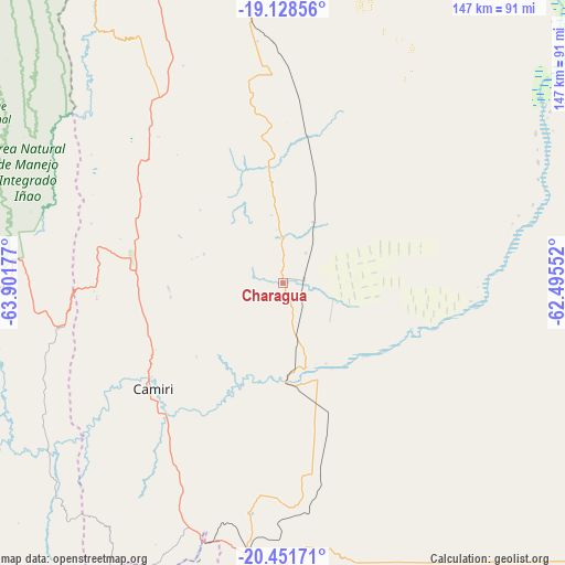
Charagua GPS coordinates[2]
19° 47' 29.436" South, 63° 11' 55.104" West
| Map corner | latitude | longitude |
|---|---|---|
| Upper-left | -19.12856°, | -63.90177° |
| Center: | -19.79151°, | -63.19864° |
| Lower-right: | -20.45171°, | -62.49552° |
| Map W x H: | 147.1×147.1 km | = 91.4×91.4mi |
| max Lat: | -9.71828° ⇑80.1% North |
| Charagua: | -19.79151° |
| min Lat: | ⇓19.9% South -22.73206° |
| min Long | Charagua | max Long |
| -69.14843° | -63.19864° | -57.76667° |
| W 86.3%⇐ | ⇒13.7% E |
Elevation
Elevation of Charagua is 799 m = 2621 ft, and this is 1212.3 m = 3977 ft below average elevation for this country.
| Max E: |
4732 m = 15525 ft | 66.5% |
| Avg. | 2011.3 m = 6599 ft | |
| Charagua | 799 m = 2621 ft | |
Min E: |
92 m = 302 ft | 33.5% |
See also: Bolivia elevation on elevation.city.
Geographical zone
Charagua is located in South Torrid zone (between Equator and Tropic of Capricorn). Distance of this Southern Tropic circle is 405.3 km =251.8 mi to South.| Distance of | km | miles | from Charagua |
|---|---|---|---|
| Equator | 2200.6 | 1367.4 | to North |
| Tropic Capricorn | 405.3 | 251.8 | to South |
| Antarctic Circle | 5200.6 | 3231.5 | to South |
| South Pole | 7806.5 | 4850.7 | to South |


Nearby cities:
15 places around Charagua: (largest is in red/bold)
• Abapó
102.8 km =63.9 mi,  349°
349°
• Azurduy
131.8 km =81.9 mi,  254°
254°
• Boyuibe
71.8 km =44.6 mi,  186°
186°
• Camatindi
134.8 km =83.8 mi, 190°
• Camiri
43.3 km =26.9 mi,  230°
230°
• Carandayti
107.5 km =66.8 mi,  172°
172°
• Huajlaya
167.2 km =103.9 mi,  237°
237°
• Monteagudo
79.1 km =49.2 mi,  269°
269°
• Padilla
127.5 km =79.2 mi,  294°
294°
• Rosario del Ingre
114.5 km =71.1 mi,  219°
219°
• San Pedro
137.6 km =85.5 mi,  278°
278°
• Sapirangui
63.1 km =39.2 mi,  255°
255°
• Tomina
155.4 km =96.6 mi,  295°
295°
• Villa Serrano
139.3 km =86.6 mi, 302°
• Villamontes
165.9 km =103.1 mi, 189°
Sources, notices
• [Note1] Compared only with cities in Bolivia existing in our database
• [Src1] Map data: © OpenStreetMap contributors (CC-BY-SA)
• [Src2] Other city data from geonames.org with taken over terms of usage.
• [Src3] Geographical zone / Annual Mean Temperature by Robert A. Rohde @ Wikipedia
