Guaporé geodata
Guaporé (Rio Grande do Sul) is a populated place; located in Brazil in America/Sao_Paulo (GMT-3) time zone. With population of 20,050 people, there are 938 cities with bigger population in this country. Compared to other cities in Brazil, 95.7% of cities are located further ↑North; 87.3% of cities are located further →East and 60.9% of cities have lower elevation than Guaporé. Note1


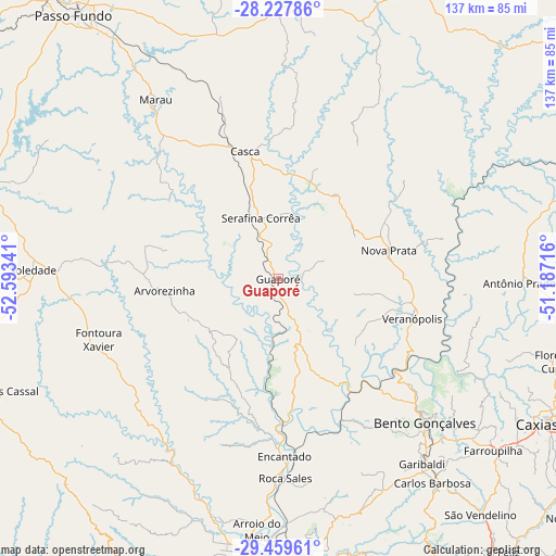
Guaporé GPS coordinates[2]
28° 50' 44.016" South, 51° 53' 25.008" West
| Map corner | latitude | longitude |
|---|---|---|
| Upper-left | -28.22786°, | -52.59341° |
| Center: | -28.84556°, | -51.89028° |
| Lower-right: | -29.45961°, | -51.18716° |
| Map W x H: | 137×137 km | = 85.1×85.1mi |
| max Lat: | 2.81972° ⇑95.7% North |
| Guaporé: | -28.84556° |
| min Lat: | ⇓4.3% South -33.69111° |
| min Long | Guaporé | max Long |
| -72.89583° | -51.89028° | -32.41083° |
| W 12.7%⇐ | ⇒87.3% E |
Elevation
Elevation of Guaporé is 482 m = 1581 ft, and this is 101.1 m = 332 ft above average elevation for this country.
| Max E: |
1603 m = 5259 ft | 39.1% |
| Guaporé | 482 m 1581 ft | |
| Avg. | 380.9 m = 1250 ft | |
Min E: |
0 m = 0 ft | 60.9% |
See also: Brazil elevation on elevation.city.
Geographical zone
Guaporé is located in South temperate zone (between Tropic of Capricorn and the Antarctic Circle). Distance of this Southern Tropic circle is 601.4 km =373.7 mi to North.| Distance of | km | miles | from Guaporé |
|---|---|---|---|
| Equator | 3207.3 | 1992.9 | to North |
| Tropic Capricorn | 601.4 | 373.7 | to North |
| Antarctic Circle | 4193.8 | 2605.9 | to South |
| South Pole | 6799.7 | 4225.1 | to South |


Nearby cities:
15 places around Guaporé: (largest is in red/bold)
• Arroio do Meio
62 km =38.5 mi,  184°
184°
• Bento Gonçalves
51.1 km =31.8 mi,  135°
135°
• Carlos Barbosa
62.7 km =39 mi, 143°
• Caxias do Sul
77.9 km =48.4 mi,  117°
117°
• Encantado
43.5 km =27 mi, 177°
• Farroupilha
67.5 km =41.9 mi,  128°
128°
• Flores da Cunha
71.9 km =44.7 mi,  106°
106°
• Garibaldi
57.3 km =35.6 mi, 142°
• Lagoa Vermelha
79.3 km =49.3 mi,  26°
26°
• Lajeado
69.4 km =43.1 mi,  185°
185°
• Marau
53.4 km =33.2 mi,  325°
325°
• Nova Prata
28.2 km =17.5 mi,  75°
75°
• Soledade
60.5 km =37.6 mi,  272°
272°
• Teutônia
67.5 km =41.9 mi,  173°
173°
• Veranópolis
34.7 km =21.6 mi, 106°
Sources, notices
• [Note1] Compared only with cities in Brazil existing in our database
• [Src1] Map data: © OpenStreetMap contributors (CC-BY-SA)
• [Src2] Other city data from geonames.org with taken over terms of usage.
• [Src3] Geographical zone / Annual Mean Temperature by Robert A. Rohde @ Wikipedia
