Araxá geodata
Araxá (Minas Gerais) is a populated place; located in Brazil in America/Sao_Paulo (GMT-3) time zone. With population of 82,595 people, there are 278 cities with bigger population in this country. Compared to other cities in Brazil, 55% of cities are located further ↑North; 58.2% of cities are located further →East and 98.3% of cities have lower elevation than Araxá. Note1


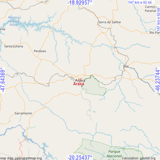
Araxá GPS coordinates[2]
19° 35' 35.988" South, 46° 56' 26.016" West
| Map corner | latitude | longitude |
|---|---|---|
| Upper-left | -18.92957°, | -47.64369° |
| Center: | -19.59333°, | -46.94056° |
| Lower-right: | -20.25437°, | -46.23744° |
| Map W x H: | 147.3×147.3 km | = 91.5×91.5mi |
| max Lat: | 2.81972° ⇑55% North |
| Araxá: | -19.59333° |
| min Lat: | ⇓45% South -33.69111° |
| min Long | Araxá | max Long |
| -72.89583° | -46.94056° | -32.41083° |
| W 41.8%⇐ | ⇒58.2% E |
Elevation
Elevation of Araxá is 1002 m = 3287 ft, and this is 621.1 m = 2038 ft above average elevation for this country.
| Max E: |
1603 m = 5259 ft | 1.7% |
| Araxá | 1002 m 3287 ft | |
| Avg. | 380.9 m = 1250 ft | |
Min E: |
0 m = 0 ft | 98.3% |
See also: Araxá elevation on elevation.city.
Geographical zone
Araxá is located in South Torrid zone (between Equator and Tropic of Capricorn). Distance of this Southern Tropic circle is 427.3 km =265.5 mi to South.| Distance of | km | miles | from Araxá |
|---|---|---|---|
| Equator | 2178.6 | 1353.7 | to North |
| Tropic Capricorn | 427.3 | 265.5 | to South |
| Antarctic Circle | 5222.6 | 3245.2 | to South |
| South Pole | 7828.5 | 4864.4 | to South |


Nearby cities:
15 places around Araxá: (largest is in red/bold)
• Bambuí
110.8 km =68.8 mi,  114°
114°
• Campos Altos
81.4 km =50.6 mi,  98°
98°
• Carmo do Paranaíba
92.9 km =57.7 mi,  44°
44°
• Cássia
110.1 km =68.4 mi,  178°
178°
• Franca
115.6 km =71.8 mi,  204°
204°
• Ibiá
44 km =27.3 mi,  73°
73°
• Igarapava
97.8 km =60.8 mi,  239°
239°
• Ituverava
120.8 km =75.1 mi,  226°
226°
• Lagoa Formosa
106.5 km =66.2 mi,  31°
31°
• Monte Carmelo
113 km =70.2 mi,  328°
328°
• Patrocínio
72.4 km =45 mi,  355°
355°
• Pedregulho
92.7 km =57.6 mi,  217°
217°
• Sacramento
60.4 km =37.5 mi, 239°
• São Gotardo
98.6 km =61.3 mi, 71°
• Uberaba
105.2 km =65.4 mi,  260°
260°
Sources, notices
• [Note1] Compared only with cities in Brazil existing in our database
• [Src1] Map data: © OpenStreetMap contributors (CC-BY-SA)
• [Src2] Other city data from geonames.org with taken over terms of usage.
• [Src3] Geographical zone / Annual Mean Temperature by Robert A. Rohde @ Wikipedia
