Uberlândia geodata
Uberlândia (Minas Gerais) is a populated place; located in Brazil in America/Sao_Paulo (GMT-3) time zone. With population of 563,536 people, there are 30 cities with bigger population in this country. Compared to other cities in Brazil, 53.1% of cities are located further ↑North; 65.9% of cities are located further →East and 93.2% of cities have lower elevation than Uberlândia. Note1


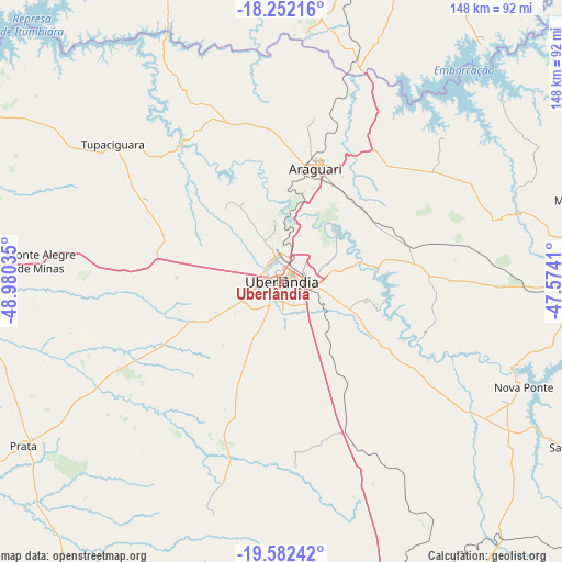
Uberlândia GPS coordinates[2]
18° 55' 6.996" South, 48° 16' 37.992" West
| Map corner | latitude | longitude |
|---|---|---|
| Upper-left | -18.25216°, | -48.98035° |
| Center: | -18.91861°, | -48.27722° |
| Lower-right: | -19.58242°, | -47.5741° |
| Map W x H: | 147.9×147.9 km | = 91.9×91.9mi |
| max Lat: | 2.81972° ⇑53.1% North |
| Uberlândia: | -18.91861° |
| min Lat: | ⇓46.9% South -33.69111° |
| min Long | Uberlândia | max Long |
| -72.89583° | -48.27722° | -32.41083° |
| W 34.1%⇐ | ⇒65.9% E |
Elevation
Elevation of Uberlândia is 867 m = 2844 ft, and this is 486.1 m = 1595 ft above average elevation for this country.
| Max E: |
1603 m = 5259 ft | 6.8% |
| Uberlândia | 867 m 2844 ft | |
| Avg. | 380.9 m = 1250 ft | |
Min E: |
0 m = 0 ft | 93.2% |
See also: Uberlândia elevation on elevation.city.
Geographical zone
Uberlândia is located in South Torrid zone (between Equator and Tropic of Capricorn). Distance of this Southern Tropic circle is 502.4 km =312.2 mi to South.| Distance of | km | miles | from Uberlândia |
|---|---|---|---|
| Equator | 2103.6 | 1307.1 | to North |
| Tropic Capricorn | 502.4 | 312.2 | to South |
| Antarctic Circle | 5297.6 | 3291.8 | to South |
| South Pole | 7903.5 | 4911 | to South |


Nearby cities:
15 places around Uberlândia: (largest is in red/bold)
• Araguari
31.6 km =19.6 mi,  17°
17°
• Buriti Alegre
118.2 km =73.4 mi,  317°
317°
• Catalão
90.7 km =56.4 mi, 22°
• Centralina
104 km =64.6 mi,  290°
290°
• Conceição das Alagoas
111.4 km =69.2 mi,  186°
186°
• Coromandel
123.8 km =76.9 mi,  66°
66°
• Ipameri
133.6 km =83 mi,  5°
5°
• Ituiutaba
124.8 km =77.5 mi,  267°
267°
• Itumbiara
113.3 km =70.4 mi,  299°
299°
• Monte Alegre de Minas
63.7 km =39.6 mi, 274°
• Monte Carmelo
84.7 km =52.6 mi,  75°
75°
• Patrocínio
135.1 km =83.9 mi,  91°
91°
• Prata
80.5 km =50 mi,  237°
237°
• Tupaciguara
57.8 km =35.9 mi,  308°
308°
• Uberaba
99.1 km =61.6 mi,  158°
158°
Sources, notices
• [Note1] Compared only with cities in Brazil existing in our database
• [Src1] Map data: © OpenStreetMap contributors (CC-BY-SA)
• [Src2] Other city data from geonames.org with taken over terms of usage.
• [Src3] Geographical zone / Annual Mean Temperature by Robert A. Rohde @ Wikipedia
