Passo Fundo geodata
Passo Fundo (Rio Grande do Sul) is a populated place; located in Brazil in America/Sao_Paulo (GMT-3) time zone. With population of 179,529 people, there are 132 cities with bigger population in this country. Compared to other cities in Brazil, 94.3% of cities are located further ↑North; 88.9% of cities are located further →East and 80.1% of cities have lower elevation than Passo Fundo. Note1


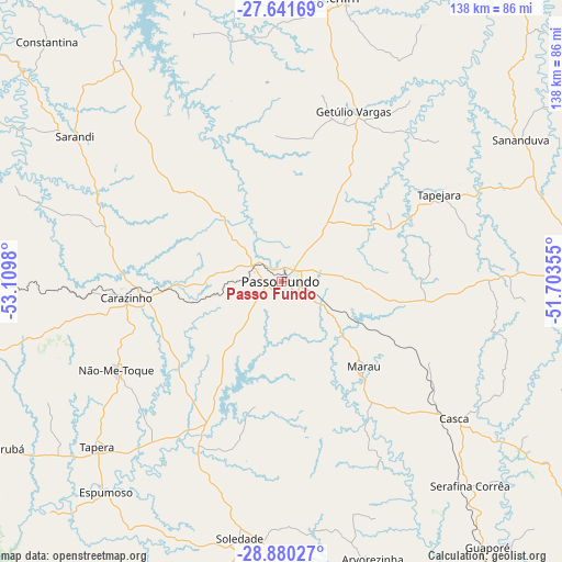
Passo Fundo GPS coordinates[2]
28° 15' 46.008" South, 52° 24' 24.012" West
| Map corner | latitude | longitude |
|---|---|---|
| Upper-left | -27.64169°, | -53.1098° |
| Center: | -28.26278°, | -52.40667° |
| Lower-right: | -28.88027°, | -51.70355° |
| Map W x H: | 137.7×137.7 km | = 85.6×85.6mi |
| max Lat: | 2.81972° ⇑94.3% North |
| Passo Fundo: | -28.26278° |
| min Lat: | ⇓5.7% South -33.69111° |
| min Long | Passo Fundo | max Long |
| -72.89583° | -52.40667° | -32.41083° |
| W 11.1%⇐ | ⇒88.9% E |
Elevation
Elevation of Passo Fundo is 689 m = 2260 ft, and this is 308.1 m = 1011 ft above average elevation for this country.
| Max E: |
1603 m = 5259 ft | 19.9% |
| Passo Fundo | 689 m 2260 ft | |
| Avg. | 380.9 m = 1250 ft | |
Min E: |
0 m = 0 ft | 80.1% |
See also: Passo Fundo elevation on elevation.city.
Geographical zone
Passo Fundo is located in South temperate zone (between Tropic of Capricorn and the Antarctic Circle). Distance of this Southern Tropic circle is 536.6 km =333.4 mi to North.| Distance of | km | miles | from Passo Fundo |
|---|---|---|---|
| Equator | 3142.5 | 1952.7 | to North |
| Tropic Capricorn | 536.6 | 333.4 | to North |
| Antarctic Circle | 4258.6 | 2646.2 | to South |
| South Pole | 6864.5 | 4265.4 | to South |


Nearby cities:
15 places around Passo Fundo: (largest is in red/bold)
• Carazinho
37.3 km =23.2 mi,  266°
266°
• Erechim
71 km =44.1 mi,  10°
10°
• Espumoso
67.2 km =41.8 mi,  220°
220°
• Guaporé
82.1 km =51 mi,  142°
142°
• Ibirubá
78.1 km =48.5 mi,  238°
238°
• Lagoa Vermelha
86.5 km =53.7 mi,  86°
86°
• Marau
29 km =18 mi, 135°
• Nova Prata
97 km =60.3 mi,  126°
126°
• Não Me Toque
46 km =28.6 mi, 241°
• Palmeira das Missões
97.7 km =60.7 mi,  294°
294°
• Panambi
107.3 km =66.7 mi, 268°
• Sananduva
68.4 km =42.5 mi,  59°
59°
• Sarandi
61.8 km =38.4 mi,  304°
304°
• Soledade
62.6 km =38.9 mi,  189°
189°
• Tapejara
44.2 km =27.5 mi, 60°
Sources, notices
• [Note1] Compared only with cities in Brazil existing in our database
• [Src1] Map data: © OpenStreetMap contributors (CC-BY-SA)
• [Src2] Other city data from geonames.org with taken over terms of usage.
• [Src3] Geographical zone / Annual Mean Temperature by Robert A. Rohde @ Wikipedia
