Marau geodata
Marau (Rio Grande do Sul) is a populated place; located in Brazil in America/Sao_Paulo (GMT-3) time zone. With population of 26,860 people, there are 736 cities with bigger population in this country. Compared to other cities in Brazil, 94.8% of cities are located further ↑North; 88.3% of cities are located further →East and 67.5% of cities have lower elevation than Marau. Note1


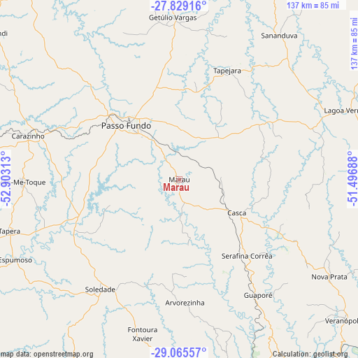
Marau GPS coordinates[2]
28° 26' 57.012" South, 52° 12' 0" West
| Map corner | latitude | longitude |
|---|---|---|
| Upper-left | -27.82916°, | -52.90313° |
| Center: | -28.44917°, | -52.2° |
| Lower-right: | -29.06557°, | -51.49688° |
| Map W x H: | 137.5×137.5 km | = 85.4×85.4mi |
| max Lat: | 2.81972° ⇑94.8% North |
| Marau: | -28.44917° |
| min Lat: | ⇓5.2% South -33.69111° |
| min Long | Marau | max Long |
| -72.89583° | -52.2° | -32.41083° |
| W 11.7%⇐ | ⇒88.3% E |
Elevation
Elevation of Marau is 553 m = 1814 ft, and this is 172.1 m = 565 ft above average elevation for this country.
| Max E: |
1603 m = 5259 ft | 32.5% |
| Marau | 553 m 1814 ft | |
| Avg. | 380.9 m = 1250 ft | |
Min E: |
0 m = 0 ft | 67.5% |
See also: Brazil elevation on elevation.city.
Geographical zone
Marau is located in South temperate zone (between Tropic of Capricorn and the Antarctic Circle). Distance of this Southern Tropic circle is 557.3 km =346.3 mi to North.| Distance of | km | miles | from Marau |
|---|---|---|---|
| Equator | 3163.3 | 1965.6 | to North |
| Tropic Capricorn | 557.3 | 346.3 | to North |
| Antarctic Circle | 4237.9 | 2633.3 | to South |
| South Pole | 6843.8 | 4252.5 | to South |


Nearby cities:
15 places around Marau: (largest is in red/bold)
• Carazinho
60.2 km =37.4 mi,  287°
287°
• Encantado
93.2 km =57.9 mi,  159°
159°
• Erechim
90.9 km =56.5 mi,  355°
355°
• Espumoso
70.4 km =43.7 mi,  244°
244°
• Guaporé
53.4 km =33.2 mi,  145°
145°
• Ibirubá
89.1 km =55.4 mi,  257°
257°
• Lagoa Vermelha
71.2 km =44.2 mi,  67°
67°
• Nova Prata
68.6 km =42.6 mi,  122°
122°
• Não Me Toque
60.7 km =37.7 mi,  268°
268°
• Passo Fundo
29 km =18 mi,  315°
315°
• Sananduva
67.6 km =42 mi,  34°
34°
• Sarandi
90.4 km =56.2 mi,  308°
308°
• Soledade
51 km =31.7 mi,  216°
216°
• Tapejara
46.1 km =28.6 mi,  23°
23°
• Veranópolis
83.4 km =51.8 mi,  130°
130°
Sources, notices
• [Note1] Compared only with cities in Brazil existing in our database
• [Src1] Map data: © OpenStreetMap contributors (CC-BY-SA)
• [Src2] Other city data from geonames.org with taken over terms of usage.
• [Src3] Geographical zone / Annual Mean Temperature by Robert A. Rohde @ Wikipedia
