Rondonópolis geodata
Rondonópolis (Mato Grosso) is a populated place; located in Brazil in America/Cuiaba (GMT-4) time zone. With population of 152,912 people, there are 151 cities with bigger population in this country. Compared to other cities in Brazil, 52.1% of cities are located further ↓South; 93.5% of cities are located further →East and 58.2% of cities have higher elevation than Rondonópolis. Note1


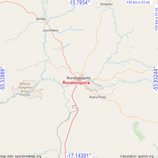
Rondonópolis GPS coordinates[2]
16° 28' 14.988" South, 54° 38' 8.016" West
| Map corner | latitude | longitude |
|---|---|---|
| Upper-left | -15.7954°, | -55.33869° |
| Center: | -16.47083°, | -54.63556° |
| Lower-right: | -17.14391°, | -53.93244° |
| Map W x H: | 149.9×149.9 km | = 93.1×93.1mi |
| max Lat: | 2.81972° ⇑47.9% North |
| Rondonópolis: | -16.47083° |
| min Lat: | ⇓52.1% South -33.69111° |
| min Long | Rondonópolis | max Long |
| -72.89583° | -54.63556° | -32.41083° |
| W 6.5%⇐ | ⇒93.5% E |
Elevation
Elevation of Rondonópolis is 230 m = 755 ft, and this is 150.9 m = 495 ft below average elevation for this country.
| Max E: |
1603 m = 5259 ft | 58.2% |
| Avg. | 380.9 m = 1250 ft | |
| Rondonópolis | 230 m = 755 ft | |
Min E: |
0 m = 0 ft | 41.8% |
See also: Rondonópolis elevation on elevation.city.
Geographical zone
Rondonópolis is located in South Torrid zone (between Equator and Tropic of Capricorn). Distance of this Southern Tropic circle is 774.5 km =481.3 mi to South.| Distance of | km | miles | from Rondonópolis |
|---|---|---|---|
| Equator | 1831.4 | 1138 | to North |
| Tropic Capricorn | 774.5 | 481.3 | to South |
| Antarctic Circle | 5569.8 | 3460.9 | to South |
| South Pole | 8175.7 | 5080.1 | to South |


Nearby cities:
15 places around Rondonópolis: (largest is in red/bold)
• Alto Araguaia
177.9 km =110.5 mi,  121°
121°
• Barra do Garças
262.1 km =162.9 mi,  75°
75°
• Barão de Melgaço
145.4 km =90.3 mi,  282°
282°
• Chapada dos Guimarães
163.7 km =101.7 mi,  313°
313°
• Coxim
226.7 km =140.9 mi,  183°
183°
• Cuiabá
184 km =114.3 mi,  301°
301°
• Guiratinga
94.2 km =58.5 mi, 81°
• Jaciara
66.5 km =41.3 mi,  327°
327°
• Lucas
139.3 km =86.6 mi, 276°
• Mineiros
253 km =157.2 mi, 118°
• Poconé
213.3 km =132.5 mi, 276°
• Portelândia
230.2 km =143 mi, 115°
• Poxoréo
75.2 km =46.7 mi,  20°
20°
• Santo Antônio do Leverger
168 km =104.4 mi,  293°
293°
• Várzea Grande
184.3 km =114.5 mi, 299°
Sources, notices
• [Note1] Compared only with cities in Brazil existing in our database
• [Src1] Map data: © OpenStreetMap contributors (CC-BY-SA)
• [Src2] Other city data from geonames.org with taken over terms of usage.
• [Src3] Geographical zone / Annual Mean Temperature by Robert A. Rohde @ Wikipedia
