Porangatu geodata
Porangatu (Goiás) is a populated place; located in Brazil in America/Sao_Paulo (GMT-3) time zone. With population of 32,758 people, there are 624 cities with bigger population in this country. Compared to other cities in Brazil, 59.2% of cities are located further ↓South; 72.6% of cities are located further →East and 53.9% of cities have lower elevation than Porangatu. Note1


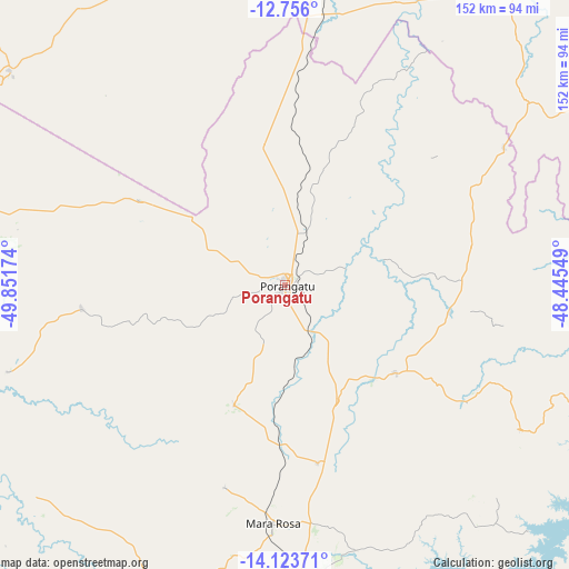
Porangatu GPS coordinates[2]
13° 26' 26.988" South, 49° 8' 54.996" West
| Map corner | latitude | longitude |
|---|---|---|
| Upper-left | -12.756°, | -49.85174° |
| Center: | -13.44083°, | -49.14861° |
| Lower-right: | -14.12371°, | -48.44549° |
| Map W x H: | 152.1×152.1 km | = 94.5×94.5mi |
| max Lat: | 2.81972° ⇑40.8% North |
| Porangatu: | -13.44083° |
| min Lat: | ⇓59.2% South -33.69111° |
| min Long | Porangatu | max Long |
| -72.89583° | -49.14861° | -32.41083° |
| W 27.4%⇐ | ⇒72.6% E |
Elevation
Elevation of Porangatu is 407 m = 1335 ft, and this is 26.1 m = 86 ft above average elevation for this country.
| Max E: |
1603 m = 5259 ft | 46.1% |
| Porangatu | 407 m 1335 ft | |
| Avg. | 380.9 m = 1250 ft | |
Min E: |
0 m = 0 ft | 53.9% |
See also: Brazil elevation on elevation.city.
Geographical zone
Porangatu is located in South Torrid zone (between Equator and Tropic of Capricorn). Distance of this Southern Tropic circle is 1111.4 km =690.6 mi to South.| Distance of | km | miles | from Porangatu |
|---|---|---|---|
| Equator | 1494.5 | 928.6 | to North |
| Tropic Capricorn | 1111.4 | 690.6 | to South |
| Antarctic Circle | 5906.7 | 3670.3 | to South |
| South Pole | 8512.6 | 5289.5 | to South |


Nearby cities:
15 places around Porangatu: (largest is in red/bold)
• Alvorada
106.9 km =66.4 mi,  1°
1°
• Barro Alto
172 km =106.9 mi,  171°
171°
• Cavalcante
186.9 km =116.1 mi,  102°
102°
• Ceres
213.2 km =132.5 mi,  193°
193°
• Crixás
151.7 km =94.3 mi,  215°
215°
• Goianésia
208.7 km =129.7 mi,  179°
179°
• Gurupi
190.5 km =118.4 mi, 2°
• Itapaci
173.4 km =107.7 mi, 194°
• Minaçu
100.9 km =62.7 mi, 95°
• Mozarlândia
211 km =131.1 mi,  226°
226°
• Niquelândia
136.8 km =85 mi,  147°
147°
• Padre Bernardo
213.3 km =132.5 mi, 154°
• Rubiataba
204.2 km =126.9 mi,  200°
200°
• São Miguel do Araguaia
111.3 km =69.2 mi,  279°
279°
• Uruaçu
120.5 km =74.9 mi, 179°
Sources, notices
• [Note1] Compared only with cities in Brazil existing in our database
• [Src1] Map data: © OpenStreetMap contributors (CC-BY-SA)
• [Src2] Other city data from geonames.org with taken over terms of usage.
• [Src3] Geographical zone / Annual Mean Temperature by Robert A. Rohde @ Wikipedia
