Piranhas geodata
Piranhas (Goiás) is a populated place; located in Brazil in America/Sao_Paulo (GMT-3) time zone. With population of 9,886 people, there are 1660 cities with bigger population in this country. Compared to other cities in Brazil, 52.4% of cities are located further ↓South; 87% of cities are located further →East and 51.1% of cities have lower elevation than Piranhas. Note1


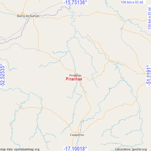
Piranhas GPS coordinates[2]
16° 25' 36.984" South, 51° 49' 19.992" West
| Map corner | latitude | longitude |
|---|---|---|
| Upper-left | -15.75136°, | -52.52535° |
| Center: | -16.42694°, | -51.82222° |
| Lower-right: | -17.10018°, | -51.1191° |
| Map W x H: | 150×150 km | = 93.2×93.2mi |
| max Lat: | 2.81972° ⇑47.6% North |
| Piranhas: | -16.42694° |
| min Lat: | ⇓52.4% South -33.69111° |
| min Long | Piranhas | max Long |
| -72.89583° | -51.82222° | -32.41083° |
| W 13%⇐ | ⇒87% E |
Elevation
Elevation of Piranhas is 366 m = 1201 ft, and this is 14.9 m = 49 ft below average elevation for this country.
| Max E: |
1603 m = 5259 ft | 48.9% |
| Avg. | 380.9 m = 1250 ft | |
| Piranhas | 366 m = 1201 ft | |
Min E: |
0 m = 0 ft | 51.1% |
See also: Brazil elevation on elevation.city.
Geographical zone
Piranhas is located in South Torrid zone (between Equator and Tropic of Capricorn). Distance of this Southern Tropic circle is 779.4 km =484.3 mi to South.| Distance of | km | miles | from Piranhas |
|---|---|---|---|
| Equator | 1826.5 | 1134.9 | to North |
| Tropic Capricorn | 779.4 | 484.3 | to South |
| Antarctic Circle | 5574.7 | 3464 | to South |
| South Pole | 8180.6 | 5083.2 | to South |


Nearby cities:
15 places around Piranhas: (largest is in red/bold)
• Alto Araguaia
178.1 km =110.7 mi,  236°
236°
• Aragarças
74.6 km =46.4 mi,  322°
322°
• Araguaiana
77.1 km =47.9 mi,  359°
359°
• Barra do Garças
75.6 km =47 mi, 322°
• Caiapônia
58.9 km =36.6 mi,  178°
178°
• Firminópolis
162.7 km =101.1 mi,  96°
96°
• Goiás
187.8 km =116.7 mi,  73°
73°
• Iporá
75.1 km =46.7 mi,  91°
91°
• Itapirapuã
145.5 km =90.4 mi,  62°
62°
• Jataí
161.9 km =100.6 mi, 176°
• Mineiros
148.8 km =92.5 mi,  211°
211°
• Paraúna
157.3 km =97.7 mi,  111°
111°
• Portelândia
137.5 km =85.4 mi,  221°
221°
• Rio Verde
179.6 km =111.6 mi,  148°
148°
• São Luís de Montes Belos
155 km =96.3 mi, 94°
Sources, notices
• [Note1] Compared only with cities in Brazil existing in our database
• [Src1] Map data: © OpenStreetMap contributors (CC-BY-SA)
• [Src2] Other city data from geonames.org with taken over terms of usage.
• [Src3] Geographical zone / Annual Mean Temperature by Robert A. Rohde @ Wikipedia
