Aragarças geodata
Aragarças (Goiás) is a populated place; located in Brazil in America/Sao_Paulo (GMT-3) time zone. With population of 16,781 people, there are 1103 cities with bigger population in this country. Compared to other cities in Brazil, 53.7% of cities are located further ↓South; 88.4% of cities are located further →East and 52.6% of cities have higher elevation than Aragarças. Note1


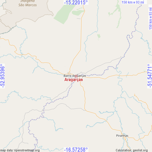
Aragarças GPS coordinates[2]
15° 53' 51" South, 52° 15' 2.988" West
| Map corner | latitude | longitude |
|---|---|---|
| Upper-left | -15.22015°, | -52.95396° |
| Center: | -15.8975°, | -52.25083° |
| Lower-right: | -16.57258°, | -51.54771° |
| Map W x H: | 150.4×150.4 km | = 93.5×93.5mi |
| max Lat: | 2.81972° ⇑46.3% North |
| Aragarças: | -15.8975° |
| min Lat: | ⇓53.7% South -33.69111° |
| min Long | Aragarças | max Long |
| -72.89583° | -52.25083° | -32.41083° |
| W 11.6%⇐ | ⇒88.4% E |
Elevation
Elevation of Aragarças is 306 m = 1004 ft, and this is 74.9 m = 246 ft below average elevation for this country.
| Max E: |
1603 m = 5259 ft | 52.6% |
| Avg. | 380.9 m = 1250 ft | |
| Aragarças | 306 m = 1004 ft | |
Min E: |
0 m = 0 ft | 47.4% |
See also: Brazil elevation on elevation.city.
Geographical zone
Aragarças is located in South Torrid zone (between Equator and Tropic of Capricorn). Distance of this Southern Tropic circle is 838.3 km =520.9 mi to South.| Distance of | km | miles | from Aragarças |
|---|---|---|---|
| Equator | 1767.6 | 1098.3 | to North |
| Tropic Capricorn | 838.3 | 520.9 | to South |
| Antarctic Circle | 5633.5 | 3500.5 | to South |
| South Pole | 8239.4 | 5119.7 | to South |


Nearby cities:
15 places around Aragarças: (largest is in red/bold)
• Alto Araguaia
188.1 km =116.9 mi,  213°
213°
• Araguaiana
48.4 km =30.1 mi,  67°
67°
• Barra do Garças
1 km =0.6 mi,  323°
323°
• Caiapônia
126.8 km =78.8 mi,  158°
158°
• Firminópolis
221.2 km =137.4 mi,  110°
110°
• Guiratinga
168.9 km =104.9 mi,  252°
252°
• Iporá
135.3 km =84.1 mi,  116°
116°
• Itapirapuã
175.3 km =108.9 mi,  87°
87°
• Mineiros
188.6 km =117.2 mi,  189°
189°
• Mozarlândia
221.1 km =137.4 mi,  54°
54°
• Nova Xavantina
137.5 km =85.4 mi,  355°
355°
• Paraúna
224.9 km =139.7 mi, 121°
• Piranhas
74.6 km =46.4 mi,  142°
142°
• Portelândia
168.2 km =104.5 mi,  195°
195°
• São Luís de Montes Belos
212.4 km =132 mi, 109°
Sources, notices
• [Note1] Compared only with cities in Brazil existing in our database
• [Src1] Map data: © OpenStreetMap contributors (CC-BY-SA)
• [Src2] Other city data from geonames.org with taken over terms of usage.
• [Src3] Geographical zone / Annual Mean Temperature by Robert A. Rohde @ Wikipedia
