Alto Araguaia geodata
Alto Araguaia (Mato Grosso) is a populated place; located in Brazil in America/Cuiaba (GMT-4) time zone. With population of 8,780 people, there are 1734 cities with bigger population in this country. Compared to other cities in Brazil, 50.3% of cities are located further ↓South; 90.8% of cities are located further →East and 78.5% of cities have lower elevation than Alto Araguaia. Note1


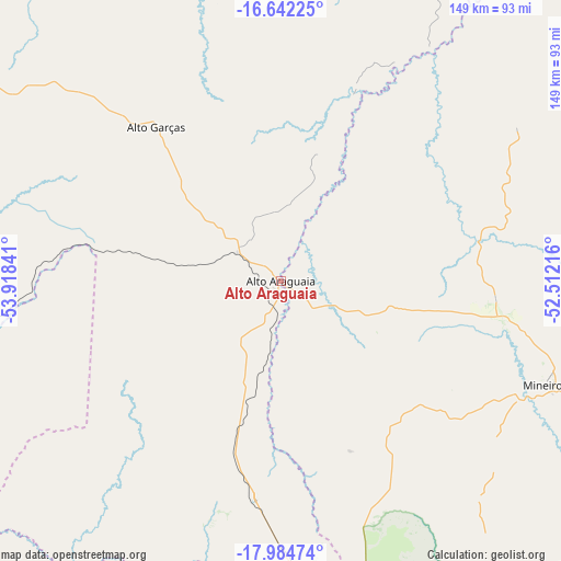
Alto Araguaia GPS coordinates[2]
17° 18' 52.992" South, 53° 12' 55.008" West
| Map corner | latitude | longitude |
|---|---|---|
| Upper-left | -16.64225°, | -53.91841° |
| Center: | -17.31472°, | -53.21528° |
| Lower-right: | -17.98474°, | -52.51216° |
| Map W x H: | 149.3×149.3 km | = 92.8×92.8mi |
| max Lat: | 2.81972° ⇑49.7% North |
| Alto Araguaia: | -17.31472° |
| min Lat: | ⇓50.3% South -33.69111° |
| min Long | Alto Araguaia | max Long |
| -72.89583° | -53.21528° | -32.41083° |
| W 9.2%⇐ | ⇒90.8% E |
Elevation
Elevation of Alto Araguaia is 672 m = 2205 ft, and this is 291.1 m = 955 ft above average elevation for this country.
| Max E: |
1603 m = 5259 ft | 21.5% |
| Alto Araguaia | 672 m 2205 ft | |
| Avg. | 380.9 m = 1250 ft | |
Min E: |
0 m = 0 ft | 78.5% |
See also: Brazil elevation on elevation.city.
Geographical zone
Alto Araguaia is located in South Torrid zone (between Equator and Tropic of Capricorn). Distance of this Southern Tropic circle is 680.7 km =423 mi to South.| Distance of | km | miles | from Alto Araguaia |
|---|---|---|---|
| Equator | 1925.2 | 1196.3 | to North |
| Tropic Capricorn | 680.7 | 423 | to South |
| Antarctic Circle | 5476 | 3402.6 | to South |
| South Pole | 8081.8 | 5021.8 | to South |


Nearby cities:
15 places around Alto Araguaia: (largest is in red/bold)
• Aragarças
188.1 km =116.9 mi,  33°
33°
• Araguaiana
229.5 km =142.6 mi,  40°
40°
• Barra do Garças
188.5 km =117.1 mi, 32°
• Caiapônia
154.5 km =96 mi,  75°
75°
• Coxim
210.4 km =130.7 mi,  230°
230°
• Guiratinga
122.5 km =76.1 mi,  331°
331°
• Iporá
243.4 km =151.2 mi,  66°
66°
• Jaciara
239.6 km =148.9 mi,  308°
308°
• Jataí
170.3 km =105.8 mi,  111°
111°
• Mineiros
75.9 km =47.2 mi, 111°
• Paraíso das Águas
190.5 km =118.4 mi,  173°
173°
• Piranhas
178.1 km =110.7 mi,  56°
56°
• Portelândia
57.1 km =35.5 mi,  94°
94°
• Poxoréo
206.5 km =128.3 mi,  322°
322°
• Rondonópolis
177.9 km =110.5 mi,  301°
301°
Sources, notices
• [Note1] Compared only with cities in Brazil existing in our database
• [Src1] Map data: © OpenStreetMap contributors (CC-BY-SA)
• [Src2] Other city data from geonames.org with taken over terms of usage.
• [Src3] Geographical zone / Annual Mean Temperature by Robert A. Rohde @ Wikipedia
