Portelândia geodata
Portelândia (Goiás) is a populated place; located in Brazil in America/Sao_Paulo (GMT-3) time zone. With population of 4,120 people, there are 1960 cities with bigger population in this country. Compared to other cities in Brazil, 50.1% of cities are located further ↓South; 89.8% of cities are located further →East and 92.8% of cities have lower elevation than Portelândia. Note1


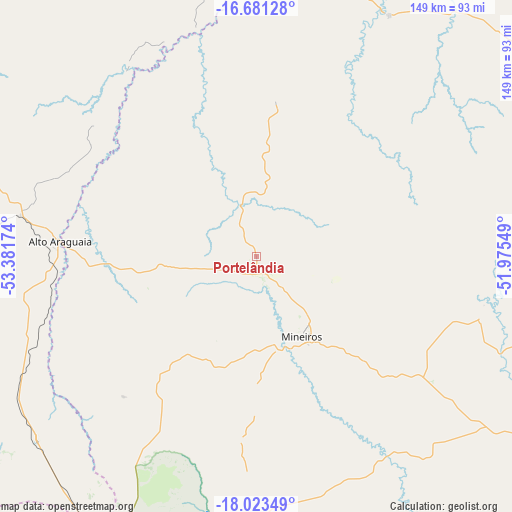
Portelândia GPS coordinates[2]
17° 21' 12.996" South, 52° 40' 42.996" West
| Map corner | latitude | longitude |
|---|---|---|
| Upper-left | -16.68128°, | -53.38174° |
| Center: | -17.35361°, | -52.67861° |
| Lower-right: | -18.02349°, | -51.97549° |
| Map W x H: | 149.2×149.2 km | = 92.7×92.7mi |
| max Lat: | 2.81972° ⇑49.9% North |
| Portelândia: | -17.35361° |
| min Lat: | ⇓50.1% South -33.69111° |
| min Long | Portelândia | max Long |
| -72.89583° | -52.67861° | -32.41083° |
| W 10.2%⇐ | ⇒89.8% E |
Elevation
Elevation of Portelândia is 857 m = 2812 ft, and this is 476.1 m = 1562 ft above average elevation for this country.
| Max E: |
1603 m = 5259 ft | 7.2% |
| Portelândia | 857 m 2812 ft | |
| Avg. | 380.9 m = 1250 ft | |
Min E: |
0 m = 0 ft | 92.8% |
See also: Brazil elevation on elevation.city.
Geographical zone
Portelândia is located in South Torrid zone (between Equator and Tropic of Capricorn). Distance of this Southern Tropic circle is 676.4 km =420.3 mi to South.| Distance of | km | miles | from Portelândia |
|---|---|---|---|
| Equator | 1929.5 | 1198.9 | to North |
| Tropic Capricorn | 676.4 | 420.3 | to South |
| Antarctic Circle | 5471.6 | 3399.9 | to South |
| South Pole | 8077.5 | 5019.1 | to South |


Nearby cities:
15 places around Portelândia: (largest is in red/bold)
• Alto Araguaia
57.1 km =35.5 mi,  274°
274°
• Aragarças
168.2 km =104.5 mi,  15°
15°
• Araguaiana
201.5 km =125.2 mi,  26°
26°
• Barra do Garças
168.8 km =104.9 mi, 15°
• Caiapônia
102.3 km =63.6 mi,  64°
64°
• Cassilândia
219.6 km =136.5 mi,  152°
152°
• Caçu
211.4 km =131.4 mi,  129°
129°
• Guiratinga
160.8 km =99.9 mi,  314°
314°
• Iporá
194.5 km =120.9 mi, 58°
• Jataí
117.1 km =72.8 mi,  119°
119°
• Mineiros
27.5 km =17.1 mi, 150°
• Paraíso das Águas
188.3 km =117 mi,  190°
190°
• Piranhas
137.5 km =85.4 mi,  41°
41°
• Rio Verde
192 km =119.3 mi,  104°
104°
• Santa Helena de Goiás
226.5 km =140.7 mi, 103°
Sources, notices
• [Note1] Compared only with cities in Brazil existing in our database
• [Src1] Map data: © OpenStreetMap contributors (CC-BY-SA)
• [Src2] Other city data from geonames.org with taken over terms of usage.
• [Src3] Geographical zone / Annual Mean Temperature by Robert A. Rohde @ Wikipedia
