Auriflama geodata
Auriflama (São Paulo) is a populated place; located in Brazil in America/Sao_Paulo (GMT-3) time zone. With population of 11,970 people, there are 1478 cities with bigger population in this country. Compared to other cities in Brazil, 61% of cities are located further ↑North; 80.6% of cities are located further →East and 60% of cities have lower elevation than Auriflama. Note1


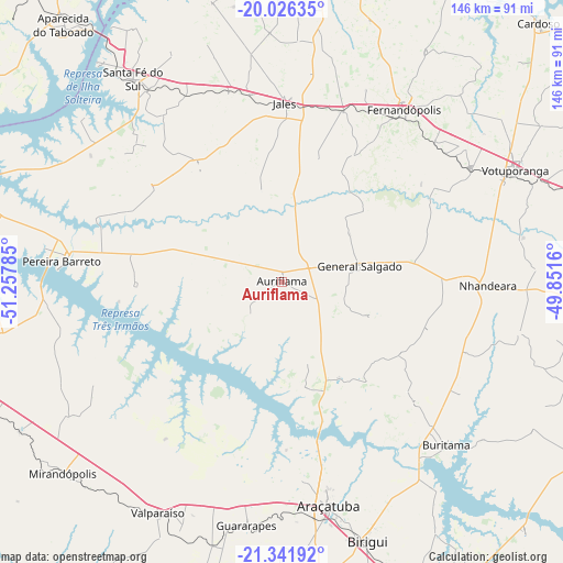
Auriflama GPS coordinates[2]
20° 41' 8.016" South, 50° 33' 16.992" West
| Map corner | latitude | longitude |
|---|---|---|
| Upper-left | -20.02635°, | -51.25785° |
| Center: | -20.68556°, | -50.55472° |
| Lower-right: | -21.34192°, | -49.8516° |
| Map W x H: | 146.3×146.3 km | = 90.9×90.9mi |
| max Lat: | 2.81972° ⇑61% North |
| Auriflama: | -20.68556° |
| min Lat: | ⇓39% South -33.69111° |
| min Long | Auriflama | max Long |
| -72.89583° | -50.55472° | -32.41083° |
| W 19.4%⇐ | ⇒80.6% E |
Elevation
Elevation of Auriflama is 473 m = 1552 ft, and this is 92.1 m = 302 ft above average elevation for this country.
| Max E: |
1603 m = 5259 ft | 40% |
| Auriflama | 473 m 1552 ft | |
| Avg. | 380.9 m = 1250 ft | |
Min E: |
0 m = 0 ft | 60% |
See also: Brazil elevation on elevation.city.
Geographical zone
Auriflama is located in South Torrid zone (between Equator and Tropic of Capricorn). Distance of this Southern Tropic circle is 305.9 km =190.1 mi to South.| Distance of | km | miles | from Auriflama |
|---|---|---|---|
| Equator | 2300 | 1429.2 | to North |
| Tropic Capricorn | 305.9 | 190.1 | to South |
| Antarctic Circle | 5101.2 | 3169.7 | to South |
| South Pole | 7707 | 4788.9 | to South |


Nearby cities:
15 places around Auriflama: (largest is in red/bold)
• Aparecida do Taboado
87.1 km =54.1 mi,  319°
319°
• Araçatuba
59.6 km =37 mi,  167°
167°
• Birigui
70.7 km =43.9 mi,  161°
161°
• Buritama
59.9 km =37.2 mi,  134°
134°
• Fernandópolis
55 km =34.2 mi,  35°
35°
• General Salgado
20.6 km =12.8 mi,  78°
78°
• Guararapes
64.6 km =40.1 mi,  188°
188°
• Ilha Solteira
86.7 km =53.9 mi,  288°
288°
• Jales
46.3 km =28.8 mi,  1°
1°
• Mirandopólis
75.6 km =47 mi,  228°
228°
• Nhandeara
53.5 km =33.2 mi,  90°
90°
• Pereira Barreto
57.9 km =36 mi,  275°
275°
• Santa Fé do Sul
65.4 km =40.6 mi, 323°
• Valparaíso
68.5 km =42.6 mi,  208°
208°
• Votuporanga
67.3 km =41.8 mi,  64°
64°
Sources, notices
• [Note1] Compared only with cities in Brazil existing in our database
• [Src1] Map data: © OpenStreetMap contributors (CC-BY-SA)
• [Src2] Other city data from geonames.org with taken over terms of usage.
• [Src3] Geographical zone / Annual Mean Temperature by Robert A. Rohde @ Wikipedia
