Palmas de Monte Alto geodata
Palmas de Monte Alto (Bahia) is a populated place; located in Brazil in America/Bahia (GMT-3) time zone. With population of 7,091 people, there are 1822 cities with bigger population in this country. Compared to other cities in Brazil, 57.7% of cities are located further ↓South; 59.6% of cities are located further ←West and 68.9% of cities have lower elevation than Palmas de Monte Alto. Note1


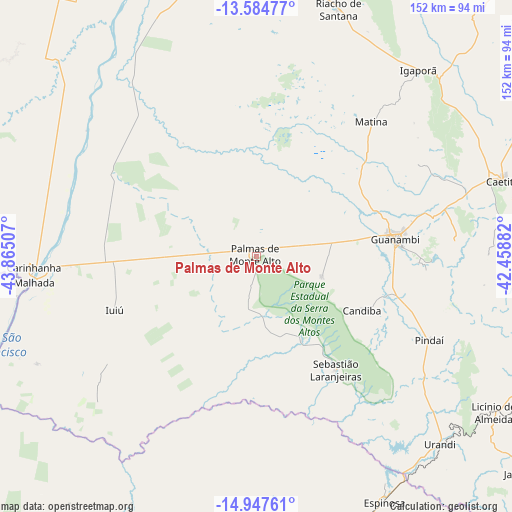
Palmas de Monte Alto GPS coordinates[2]
14° 16' 1.992" South, 43° 9' 42.984" West
| Map corner | latitude | longitude |
|---|---|---|
| Upper-left | -13.58477°, | -43.86507° |
| Center: | -14.26722°, | -43.16194° |
| Lower-right: | -14.94761°, | -42.45882° |
| Map W x H: | 151.5×151.5 km | = 94.1×94.1mi |
| max Lat: | 2.81972° ⇑42.3% North |
| Palmas de Monte Alto: | -14.26722° |
| min Lat: | ⇓57.7% South -33.69111° |
| min Long | Palmas de Monte | max Long |
| -72.89583° | -43.16194° | -32.41083° |
| W 59.6%⇐ | ⇒40.4% E |
Elevation
Elevation of Palmas de Monte Alto is 565 m = 1854 ft, and this is 184.1 m = 604 ft above average elevation for this country.
| Max E: |
1603 m = 5259 ft | 31.1% |
| Palmas de Monte Alto | 565 m 1854 ft | |
| Avg. | 380.9 m = 1250 ft | |
Min E: |
0 m = 0 ft | 68.9% |
See also: Brazil elevation on elevation.city.
Geographical zone
Palmas de Monte Alto is located in South Torrid zone (between Equator and Tropic of Capricorn). Distance of this Southern Tropic circle is 1019.6 km =633.5 mi to South.| Distance of | km | miles | from Palmas de Monte Alto |
|---|---|---|---|
| Equator | 1586.4 | 985.7 | to North |
| Tropic Capricorn | 1019.6 | 633.5 | to South |
| Antarctic Circle | 5814.8 | 3613.1 | to South |
| South Pole | 8420.7 | 5232.4 | to South |


Nearby cities:
15 places around Palmas de Monte Alto: (largest is in red/bold)
• Bom Jesus da Lapa
115.9 km =72 mi,  346°
346°
• Caculé
104.6 km =65 mi,  104°
104°
• Caetité
77.3 km =48 mi,  73°
73°
• Carinhanha
65.1 km =40.5 mi,  266°
266°
• Espinosa
82 km =51 mi,  153°
153°
• Guanambi
41.3 km =25.7 mi,  83°
83°
• Itacarambi
136.5 km =84.8 mi,  227°
227°
• Macaúbas
147.5 km =91.7 mi,  19°
19°
• Manga
99.1 km =61.6 mi,  236°
236°
• Mato Verde
129.6 km =80.5 mi,  165°
165°
• Monte Azul
103.4 km =64.2 mi,  162°
162°
• Paramirim
135.4 km =84.1 mi,  47°
47°
• Riacho de Santana
77 km =47.8 mi, 18°
• Santa Maria da Vitória
148.6 km =92.3 mi,  311°
311°
• Santana
148.4 km =92.2 mi, 98°
Sources, notices
• [Note1] Compared only with cities in Brazil existing in our database
• [Src1] Map data: © OpenStreetMap contributors (CC-BY-SA)
• [Src2] Other city data from geonames.org with taken over terms of usage.
• [Src3] Geographical zone / Annual Mean Temperature by Robert A. Rohde @ Wikipedia
