Campina Verde geodata
Campina Verde (Minas Gerais) is a populated place; located in Brazil in America/Sao_Paulo (GMT-3) time zone. With population of 13,137 people, there are 1361 cities with bigger population in this country. Compared to other cities in Brazil, 54.7% of cities are located further ↑North; 75.4% of cities are located further →East and 67.3% of cities have lower elevation than Campina Verde. Note1


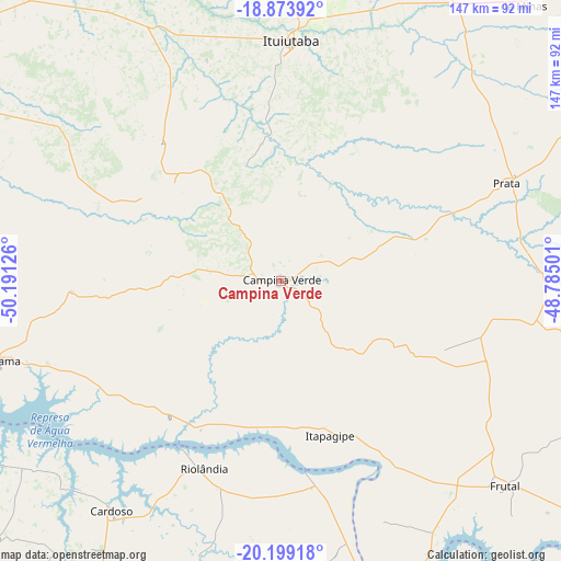
Campina Verde GPS coordinates[2]
19° 32' 16.476" South, 49° 29' 17.268" West
| Map corner | latitude | longitude |
|---|---|---|
| Upper-left | -18.87392°, | -50.19126° |
| Center: | -19.53791°, | -49.48813° |
| Lower-right: | -20.19918°, | -48.78501° |
| Map W x H: | 147.4×147.4 km | = 91.6×91.6mi |
| max Lat: | 2.81972° ⇑54.7% North |
| Campina Verde: | -19.53791° |
| min Lat: | ⇓45.3% South -33.69111° |
| min Long | Campina Verde | max Long |
| -72.89583° | -49.48813° | -32.41083° |
| W 24.6%⇐ | ⇒75.4% E |
Elevation
Elevation of Campina Verde is 549 m = 1801 ft, and this is 168.1 m = 552 ft above average elevation for this country.
| Max E: |
1603 m = 5259 ft | 32.7% |
| Campina Verde | 549 m 1801 ft | |
| Avg. | 380.9 m = 1250 ft | |
Min E: |
0 m = 0 ft | 67.3% |
See also: Brazil elevation on elevation.city.
Geographical zone
Campina Verde is located in South Torrid zone (between Equator and Tropic of Capricorn). Distance of this Southern Tropic circle is 433.5 km =269.4 mi to South.| Distance of | km | miles | from Campina Verde |
|---|---|---|---|
| Equator | 2172.4 | 1349.9 | to North |
| Tropic Capricorn | 433.5 | 269.4 | to South |
| Antarctic Circle | 5228.8 | 3249 | to South |
| South Pole | 7834.6 | 4868.2 | to South |


Nearby cities:
15 places around Campina Verde: (largest is in red/bold)
• Capinópolis
95.6 km =59.4 mi,  354°
354°
• Cardoso
75.1 km =46.7 mi,  216°
216°
• Centralina
110.3 km =68.5 mi,  15°
15°
• Conceição das Alagoas
122.5 km =76.1 mi,  110°
110°
• Fernandópolis
114.7 km =71.3 mi, 223°
• Frutal
78.8 km =49 mi,  133°
133°
• Ituiutaba
62.7 km =39 mi,  2°
2°
• Iturama
77 km =47.8 mi,  254°
254°
• Monte Alegre de Minas
97.8 km =60.8 mi,  40°
40°
• Nova Granada
112.2 km =69.7 mi,  170°
170°
• Prata
64.5 km =40.1 mi,  66°
66°
• Riolândia
53.3 km =33.1 mi,  202°
202°
• Santa Vitória
102.3 km =63.6 mi,  319°
319°
• Tanabi
122.2 km =75.9 mi,  187°
187°
• Votuporanga
110.7 km =68.8 mi,  207°
207°
Sources, notices
• [Note1] Compared only with cities in Brazil existing in our database
• [Src1] Map data: © OpenStreetMap contributors (CC-BY-SA)
• [Src2] Other city data from geonames.org with taken over terms of usage.
• [Src3] Geographical zone / Annual Mean Temperature by Robert A. Rohde @ Wikipedia
