Estrela geodata
Estrela (Rio Grande do Sul) is a populated locality; located in Brazil in America/Sao_Paulo (GMT-3) time zone. With population of 24,200 people, there are 802 cities with bigger population in this country. Compared to other cities in Brazil, 94% of cities are located further ↑North; 82.1% of cities are located further →East and 95.6% of cities have lower elevation than Estrela. Note1


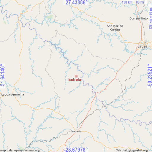
Estrela GPS coordinates[2]
28° 3' 39.996" South, 50° 56' 17.988" West
| Map corner | latitude | longitude |
|---|---|---|
| Upper-left | -27.43886°, | -51.64146° |
| Center: | -28.06111°, | -50.93833° |
| Lower-right: | -28.67978°, | -50.23521° |
| Map W x H: | 138×138 km | = 85.7×85.7mi |
| max Lat: | 2.81972° ⇑94% North |
| Estrela: | -28.06111° |
| min Lat: | ⇓6% South -33.69111° |
| min Long | Estrela | max Long |
| -72.89583° | -50.93833° | -32.41083° |
| W 17.9%⇐ | ⇒82.1% E |
Elevation
Elevation of Estrela is 910 m = 2986 ft, and this is 529.1 m = 1736 ft above average elevation for this country.
| Max E: |
1603 m = 5259 ft | 4.4% |
| Estrela | 910 m 2986 ft | |
| Avg. | 380.9 m = 1250 ft | |
Min E: |
0 m = 0 ft | 95.6% |
See also: Brazil elevation on elevation.city.
Geographical zone
Estrela is located in South temperate zone (between Tropic of Capricorn and the Antarctic Circle). Distance of this Southern Tropic circle is 514.2 km =319.5 mi to North.| Distance of | km | miles | from Estrela |
|---|---|---|---|
| Equator | 3120.1 | 1938.7 | to North |
| Tropic Capricorn | 514.2 | 319.5 | to North |
| Antarctic Circle | 4281.1 | 2660.2 | to South |
| South Pole | 6887 | 4279.4 | to South |


Nearby cities:
15 places around Estrela: (largest is in red/bold)
• Campos Novos
78.6 km =48.8 mi,  338°
338°
• Capinzal
103.7 km =64.4 mi,  320°
320°
• Celso Ramos
61.5 km =38.2 mi, 320°
• Correia Pinto
77.6 km =48.2 mi,  46°
46°
• Curitibanos
93.3 km =58 mi,  21°
21°
• Flores da Cunha
110.2 km =68.5 mi,  192°
192°
• Lages
66 km =41 mi,  65°
65°
• Lagoa Vermelha
59.9 km =37.2 mi,  254°
254°
• Nova Prata
103.8 km =64.5 mi,  219°
219°
• Otacílio Costa
102.9 km =63.9 mi, 51°
• Sananduva
86.1 km =53.5 mi,  278°
278°
• São Joaquim
102 km =63.4 mi,  104°
104°
• São Marcos
102 km =63.4 mi, 187°
• Tapejara
105.5 km =65.6 mi,  269°
269°
• Vacaria
50.2 km =31.2 mi,  179°
179°
Sources, notices
• [Note1] Compared only with cities in Brazil existing in our database
• [Src1] Map data: © OpenStreetMap contributors (CC-BY-SA)
• [Src2] Other city data from geonames.org with taken over terms of usage.
• [Src3] Geographical zone / Annual Mean Temperature by Robert A. Rohde @ Wikipedia
